IMAGES TAKEN NEAR TO
Fox Close, FOLKESTONE, CT18 8EZ
Introduction
This page details the photographs taken nearby to Fox Close, CT18 8EZ by members of the Geograph project.
The Geograph project started in 2005 with the aim of publishing, organising and preserving representative images for every square kilometre of Great Britain, Ireland and the Isle of Man.

There are currently over 7.5m images from over14,400 individuals and you can help contribute to the project by visiting https://www.geograph.org.uk
Image Map
Images are licensed for reuse under creativecommons.org/licenses/by-sa/2.0
Notes
- Clicking on the map will re-center to the selected point.
- The higher the marker number, the further away the image location is from the centre of the postcode.
Image Listing (11 Images Found)
Images are licensed for reuse under creativecommons.org/licenses/by-sa/2.0
Image
Details
Distance
1
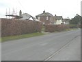
Looking north-northeast along Brady Road
The bungalow “Hill View” has had scaffolding erected to chimney level, while the most distant house in this view, “Little Garth”, has had scaffolding erected to ridge level.
Image: © John Baker
Taken: 4 Mar 2014
0.11 miles
2
Wood Lodge, Brady Road
Planning permission has been approved, with conditions, by Folkestone and Hythe District Council under application number Y17/0625/SH for the “change of use of integral garage to living accommodation and erection of a detached garage with first floor space to be used as a study”.
Image: © John Baker
Taken: 21 Mar 2018
0.14 miles
3
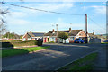
Bungalows on Silverlands Road
A turning off Palm Tree Way in the quite extensive enlargement of the village to the north.
Image: © Robin Webster
Taken: 28 Dec 2015
0.16 miles
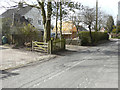
4
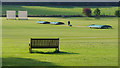
Bench and stile
At junction of Woodland Road and Brady Road. A short footpath connects to Skeete Road.
Image: © Oast House Archive
Taken: 10 Jul 2010
0.17 miles
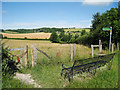
5
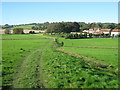
Footpath to Sibton Park
This path leads from Brady Road. Past the Country Club and Longage Farm towards Longage Hill.
The house on the right is Sibton House Country House, used for holiday lets. See http://www.hpb-sibtonpark.co.uk/Default.aspx for more info.
Image: © David Anstiss
Taken: 10 Oct 2010
0.17 miles
6
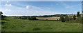
Panorama of Skeet and Woodland
As seen from Image
A footpath leads through the field towards Skeet Road and the small village of Skeet on the left.
On the right, across the valley is the village of Woodland on Woodland Road.
Image: © David Anstiss
Taken: 7 Oct 2012
0.20 miles
7
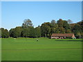
Sibton Park Cricket Club
As seen from a footpath from Brady Road towards Longage Hill.
See http://en.wikipedia.org/wiki/Sibton_Park_Cricket_Club for more details on this old club, established since the 1880's.
Image: © David Anstiss
Taken: 10 Oct 2010
0.21 miles
8
Sibton Park Cricket Club - the pitch
Sibton Park Cricket Club was formed under the patronage of John Howard in 1903 http://en.wikipedia.org/wiki/Sibton_Park_Cricket_Club
Image: © John Baker
Taken: 26 Aug 2012
0.23 miles
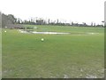
9
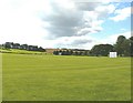
Sibton Park cricket ground
The groundsman is mowing the wicket.
Image: © Ian Taylor
Taken: 2 Sep 2017
0.23 miles
10
Sibton Park Cricket Club?s flooded pitch
This was the result of weeks of torrential rain, when groundwater had accumulated at this spot having drained from the upward-sloping land behind the pitch. A channel had been dug, beyond the white notice on the left, in an attempt get rid of the water, which then flowed to a drain under Longage Hill.
Image: © John Baker
Taken: 4 Mar 2014
0.24 miles