IMAGES TAKEN NEAR TO
Skeete Road, FOLKESTONE, CT18 8DS
Introduction
This page details the photographs taken nearby to Skeete Road, CT18 8DS by members of the Geograph project.
The Geograph project started in 2005 with the aim of publishing, organising and preserving representative images for every square kilometre of Great Britain, Ireland and the Isle of Man.

There are currently over 7.5m images from over14,400 individuals and you can help contribute to the project by visiting https://www.geograph.org.uk
Image Map
Images are licensed for reuse under creativecommons.org/licenses/by-sa/2.0
Notes
- Clicking on the map will re-center to the selected point.
- The higher the marker number, the further away the image location is from the centre of the postcode.
Image Listing (11 Images Found)
Images are licensed for reuse under creativecommons.org/licenses/by-sa/2.0
Image
Details
Distance
5
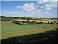
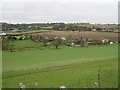
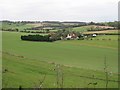
Fields off Brady Road
View to Little Hollow Farm and Valley Farm which are on Skeete Road.
Image: © Oast House Archive
Taken: 10 Jul 2010
0.15 miles
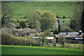
7
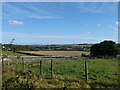
View of Lyminge
As seen from Image, close to Skeete Road.
Houses on Woodlands Road can be seen on the left.
Image: © David Anstiss
Taken: 7 Oct 2012
0.19 miles
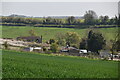
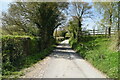
9
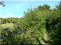
Bridleway to Woodland
This track leads up from Skeete Road.
Woodland is a small village near Lyminge.
Image: © David Anstiss
Taken: 7 Oct 2012
0.20 miles
