IMAGES TAKEN NEAR TO
Farthing Common, FOLKESTONE, CT18 8DQ
Introduction
This page details the photographs taken nearby to Farthing Common, CT18 8DQ by members of the Geograph project.
The Geograph project started in 2005 with the aim of publishing, organising and preserving representative images for every square kilometre of Great Britain, Ireland and the Isle of Man.

There are currently over 7.5m images from over14,400 individuals and you can help contribute to the project by visiting https://www.geograph.org.uk
Image Map
Images are licensed for reuse under creativecommons.org/licenses/by-sa/2.0
Notes
- Clicking on the map will re-center to the selected point.
- The higher the marker number, the further away the image location is from the centre of the postcode.
Image Listing (6 Images Found)
Images are licensed for reuse under creativecommons.org/licenses/by-sa/2.0
Image
Details
Distance
1
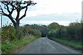
Road towards Lyminge and Etchinghill
Routes diverge at the end of the straight, Lyminge to the left.
Image: © Robin Webster
Taken: 13 Oct 2018
0.08 miles
2
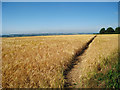
Golden Wheat Field
Footpath connecting to the North Downs Way.
Image: © Oast House Archive
Taken: 10 Jul 2010
0.15 miles
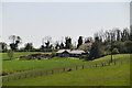
4
Footpath to Farthing Common
This path leads from the North Downs Way (long distance path) towards the road near Postling Wood.
Compare with Image
Image: © David Anstiss
Taken: 7 Oct 2012
0.19 miles
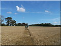
5
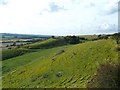
North Downs near Postling
The North Downs Way (long distance path) passes through this amazing valley near Postling, on a bridleway towards Farthing Common.
Another bridleway leads left towards the Pilgrims Way.
Image: © David Anstiss
Taken: 7 Oct 2012
0.22 miles
6
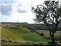
North Downs near Postling
The North Downs Way (long distance path) passes around this amazing valley near Postling.
Image: © David Anstiss
Taken: 7 Oct 2012
0.23 miles