IMAGES TAKEN NEAR TO
Newington, FOLKESTONE, CT18 8BH
Introduction
This page details the photographs taken nearby to CT18 8BH by members of the Geograph project.
The Geograph project started in 2005 with the aim of publishing, organising and preserving representative images for every square kilometre of Great Britain, Ireland and the Isle of Man.

There are currently over 7.5m images from over14,400 individuals and you can help contribute to the project by visiting https://www.geograph.org.uk
Image Map
Images are licensed for reuse under creativecommons.org/licenses/by-sa/2.0
Notes
- Clicking on the map will re-center to the selected point.
- The higher the marker number, the further away the image location is from the centre of the postcode.
Image Listing (16 Images Found)
Images are licensed for reuse under creativecommons.org/licenses/by-sa/2.0
Image
Details
Distance
1
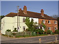
Row of cottages
Bargrove Cottages from entrance to Folkestone Rugby ground across Blackhouse Hill Lane.
Image: © D-G-Seamon
Taken: 3 May 2007
0.09 miles

3
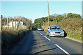
Road north towards the A20
Approaching Bargrove Cottages.
Image: © Robin Webster
Taken: 18 Nov 2018
0.09 miles
4
Saltwood - 2007
Saltwood, Bargrove, Blackhouse Hill, Bargrove Wood
Image: © Helmut Zozmann
Taken: 27 Jul 2007
0.09 miles
5
Saltwood - 2007
Saltwood, Bargrove, Blackhouse Hill, Bargrove Wood
Image: © Helmut Zozmann
Taken: 27 Jul 2007
0.10 miles
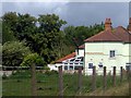
6
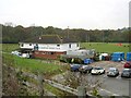
Folkestone Rugby Club clubhouse and grounds
One decent kick and you'd be collecting your ball from here!
Image
Image: © Nick Smith
Taken: 13 Nov 2007
0.10 miles
7
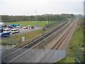
Looking W along the railway line towards Ashford
Image: © Nick Smith
Taken: 13 Nov 2007
0.13 miles
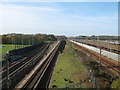
8
Looking W along the railway tracks near Bargrove
A multitude of tracks through here, some for the Eurotunnel and others for the Folkestone / Ashford / London line.
Image: © Nick Smith
Taken: 13 Nov 2007
0.13 miles
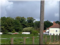
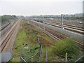
9
Railway lines from the CTRL Cheriton Terminus
As seen from Image
On the right is the EWS Railway freight sidings.
Then before the grey fence, two freight lines head from the Channel Tunnel towards the High Speed Link. Then the Eurostar line leads (running the opposite way) from the Eurotunnel towards Kent. Then lastly the line on the left, is the mainline heading from Folkestone West towards Ashford.
On the far left, Folkestone Rugby Club can just be seen, with Bargrove Wood in the background.
Image: © David Anstiss
Taken: 19 Nov 2010
0.15 miles
10
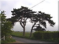
Two pines
Two pines near the top of Blackhouse Hill.
Image: © D-G-Seamon
Taken: 3 May 2007
0.17 miles