IMAGES TAKEN NEAR TO
Woodland Drive, FOLKESTONE, CT18 7ST
Introduction
This page details the photographs taken nearby to Woodland Drive, CT18 7ST by members of the Geograph project.
The Geograph project started in 2005 with the aim of publishing, organising and preserving representative images for every square kilometre of Great Britain, Ireland and the Isle of Man.

There are currently over 7.5m images from over14,400 individuals and you can help contribute to the project by visiting https://www.geograph.org.uk
Image Map
Images are licensed for reuse under creativecommons.org/licenses/by-sa/2.0
Notes
- Clicking on the map will re-center to the selected point.
- The higher the marker number, the further away the image location is from the centre of the postcode.
Image Listing (25 Images Found)
Images are licensed for reuse under creativecommons.org/licenses/by-sa/2.0
Image
Details
Distance
2
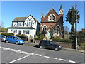
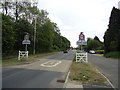
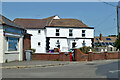
18, The Street
It was formerly known as Union Chapel, was opened on 23 May 1833 and cost £400 to build. In 1873, extensive alterations and improvements took place. The stained glass windows were a memorial to John Clarke, the foundling pastor, who had died in 1850. Subsequently it became the Hawkinge Free Church (Baptist). The Gothic tower holds a clock dedicated as a war memorial to two World Wars.
Image: © John Baker
Taken: 5 Apr 2015
0.07 miles
3
Land Adjoining 45, The Street
Planning permission has been approved, with conditions, by Folkestone and Hythe District Council under application number 22/0268/FH for the “erection of a 2 storey, 4 bedroom detached dwelling with garage and formation of new access and associated landscaping”.
Image: © John Baker
Taken: 23 Jul 2022
0.10 miles
4
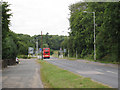
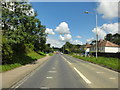
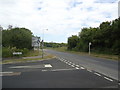
Bus on Canterbury Road
Approaching new roundabout with Spitfire Way.
Image: © Oast House Archive
Taken: 17 Jul 2010
0.10 miles
6
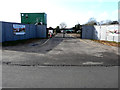
Windmill Close, Mill Lane, Hawkinge
This was Image in March 2020.
Image: © John Baker
Taken: 9 Jan 2022
0.13 miles
7
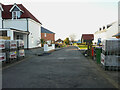
Windmill Close, Mill Lane, Hawkinge
Planning permission has been approved, with conditions, by Folkestone and Hythe District Council under application number Y18/0555/FH for the “erection of a residential development of 14 houses with associated access being details pursuant to outline planning permission Y15/0741/SH (details relating to appearance, landscaping, layout and scale) resubmission of planning application Y17/1050/SH, together with discharging planning conditions 8, 17 and 24”.
The houses are being built on land which was sold by Mill Farm, Mill Lane, Hawkinge to a developer.
Image: © John Baker
Taken: 1 Mar 2020
0.13 miles
10
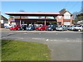
Radnor Garage, Canterbury Road
Radnor Garage was built for Lawrence Brisley by his brother David in 1932. Although it no longer sells either petrol or diesel for vehicles, the pumps are still there.
Image: © John Baker
Taken: 5 Apr 2015
0.15 miles