IMAGES TAKEN NEAR TO
Meadow Close, FOLKESTONE, CT18 7PS
Introduction
This page details the photographs taken nearby to Meadow Close, CT18 7PS by members of the Geograph project.
The Geograph project started in 2005 with the aim of publishing, organising and preserving representative images for every square kilometre of Great Britain, Ireland and the Isle of Man.

There are currently over 7.5m images from over14,400 individuals and you can help contribute to the project by visiting https://www.geograph.org.uk
Image Map
Images are licensed for reuse under creativecommons.org/licenses/by-sa/2.0
Notes
- Clicking on the map will re-center to the selected point.
- The higher the marker number, the further away the image location is from the centre of the postcode.
Image Listing (39 Images Found)
Images are licensed for reuse under creativecommons.org/licenses/by-sa/2.0
Image
Details
Distance
1

Hawkinge Village Sign
On small green in between Mill Lane and A260 Canterbury Road. Building on left is Nat West Bank. Sign with airforce symbol due to Battle of Britain Museum in Village. This sign is very easy to miss, very poorly placed.
Image: © David Anstiss
Taken: 31 Jan 2009
0.13 miles
2
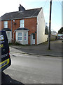
2, Mill Lane, Hawkinge
Planning permission has been approved, with conditions, by Folkestone and Hythe District Council under application number Y19/1289/FH for the “erection of single storey rear and side extension, a first floor rear extension, plus dormer window to attic and roof light. External cladding in grey fibre cement board. Re-submission of Y19/0969/FH”.
Image: © John Baker
Taken: 1 Mar 2020
0.13 miles
3

St Luke's Church, Hawkinge
The Parish Church of Hawkinge. On A260 Canterbury Road.
Image: © David Anstiss
Taken: 31 Jan 2009
0.14 miles
4
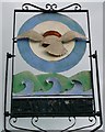
Hawkinge Village Sign (close-up)
Close-up of Image
Has an airforce symbol due to Battle of Britain Museum being in the village.
Shows the waves and the North Downs.
Image: © David Anstiss
Taken: 7 Oct 2012
0.14 miles
5
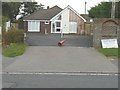
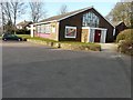
Hawkinge and Elham Valley Practice, Canterbury Road
As well as bearing the title of this image, the notice-board also bears the words “refurbishment and extension to Hawkinge Health Centre completed 2013”. In the past, there used to a Portakabin in front of the main building.
Image: © John Baker
Taken: 10 Aug 2014
0.15 miles
6
Hawkinge & Elham Valley Practice, 74 Canterbury Road
Image: © John Baker
Taken: 6 Feb 2022
0.15 miles
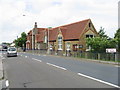
7
St Luke?s church, Canterbury Road
It was built in 1958 to replace a church clad in corrugated tin sheeting, that had been erected in 1889 and had been damaged by a fire, which had partially destroyed the front of the building. The church is located next door and to the left of Image
Image: © John Baker
Taken: 1 Mar 2015
0.15 miles
8
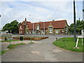
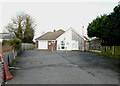
Hawkinge primary school
Taken from the car park of the village hall.
Image: © Nick Smith
Taken: 20 Jun 2008
0.16 miles
10
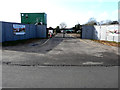
Windmill Close, Mill Lane, Hawkinge
Planning permission has been approved, with conditions, by Folkestone and Hythe District Council under application number Y18/0555/FH for the “erection of a residential development of 14 houses with associated access being details pursuant to outline planning permission Y15/0741/SH (details relating to appearance, landscaping, layout and scale) resubmission of planning application Y17/1050/SH, together with discharging planning conditions 8, 17 and 24”.
The houses are being built on land which was sold by Mill Farm, Mill Lane, Hawkinge to a developer.
Image: © John Baker
Taken: 1 Mar 2020
0.16 miles