IMAGES TAKEN NEAR TO
Downs Close, FOLKESTONE, CT18 7PA
Introduction
This page details the photographs taken nearby to Downs Close, CT18 7PA by members of the Geograph project.
The Geograph project started in 2005 with the aim of publishing, organising and preserving representative images for every square kilometre of Great Britain, Ireland and the Isle of Man.

There are currently over 7.5m images from over14,400 individuals and you can help contribute to the project by visiting https://www.geograph.org.uk
Image Map
Images are licensed for reuse under creativecommons.org/licenses/by-sa/2.0
Notes
- Clicking on the map will re-center to the selected point.
- The higher the marker number, the further away the image location is from the centre of the postcode.
Image Listing (58 Images Found)
Images are licensed for reuse under creativecommons.org/licenses/by-sa/2.0
Image
Details
Distance
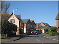
2
Haven Drive, Hawkinge
During the construction of the estate, a mound of earth, about 15 feet high, was left to the south of Haven Drive. This has been grassed over and planted with trees to form a viewpoint and this is where this view was taken from.
Image: © John Baker
Taken: 15 Apr 2011
0.11 miles
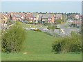
3
Aerodrome Road approaches roundabout junction with Haven Drive
Image: © Stuart Logan
Taken: 4 Apr 2014
0.12 miles
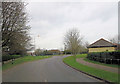
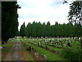
4
Path in Hawkinge Cemetery
Many paths criss-cross this large cemetery.
Access roads are flanked by yew trees.
Image: © David Anstiss
Taken: 7 Oct 2012
0.16 miles
5
Path in Hawkinge Cemetery (2)
Many paths criss-cross this large cemetery.
Access roads are flanked by yew trees.
Image: © David Anstiss
Taken: 7 Oct 2012
0.16 miles
6
A corner of Hawkinge Cemetery
The end of a marginal strip with no graves.
Image: © Robin Webster
Taken: 16 Jan 2013
0.16 miles
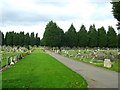
7
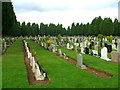
Hawkinge Cemetery
Rows and rows of graves, bounded by large yew trees.
Image: © David Anstiss
Taken: 7 Oct 2012
0.17 miles
8
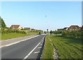
Pedestrian crossing, Spitfire Way, Hawkinge
Of interest, as far as I am concerned, is how large the trees and shrubs, that were planted along both sides of the road, have got.
Image: © John Baker
Taken: 28 May 2012
0.17 miles
9
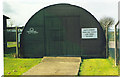
Kent Battle of Britain Museum, Hawkinge
Another of the original structures - complete with Kilroy - or Foo.
Image: © Ron Hann
Taken: Unknown
0.18 miles
10
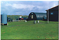
Kent Battle of Britain Museum, Hawkinge
Some of the buildings used to house the exhibits.
Image: © Ron Hann
Taken: Unknown
0.18 miles