IMAGES TAKEN NEAR TO
Canterbury Road, FOLKESTONE, CT18 7JA
Introduction
This page details the photographs taken nearby to Canterbury Road, CT18 7JA by members of the Geograph project.
The Geograph project started in 2005 with the aim of publishing, organising and preserving representative images for every square kilometre of Great Britain, Ireland and the Isle of Man.

There are currently over 7.5m images from over14,400 individuals and you can help contribute to the project by visiting https://www.geograph.org.uk
Image Map
Images are licensed for reuse under creativecommons.org/licenses/by-sa/2.0
Notes
- Clicking on the map will re-center to the selected point.
- The higher the marker number, the further away the image location is from the centre of the postcode.
Image Listing (21 Images Found)
Images are licensed for reuse under creativecommons.org/licenses/by-sa/2.0
Image
Details
Distance

2
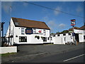
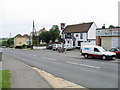
The White Horse, Hawkinge
A Shepherd Neame pub on Canterbury Road.
Image: © Oast House Archive
Taken: 17 Jul 2010
0.03 miles
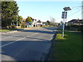
3
View along the old A260, Canterbury Road
Image: © Nick Smith
Taken: 20 Jun 2008
0.04 miles
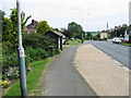
4
Looking east-southeast along Canterbury Road
Just beyond the bus shelter is Image
Image: © John Baker
Taken: 15 Feb 2015
0.04 miles
6
The White Horse on the Canterbury Road, Hawkinge
Image: © Nick Smith
Taken: 20 Jun 2008
0.05 miles
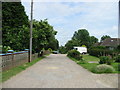
8
Coombe Wood Lane
Seen from Canterbury Road, this road’s surface has some stretches of tarmac, while the rest is unmade.
Image: © John Baker
Taken: 15 Feb 2015
0.07 miles
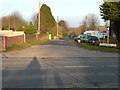
9

Old Milestone by Canterbury Road, Hawkinge
Carved stone post by the A260, in parish of HAWKINGE (SHEPWAY District), Canterbury Road, just North of junction with Coombe Wood Lane, by Milestone Caravans, in grass behind pavement with back to wall, on East side of road. Barham road stone, erected by the Folkestone & Barham turnpike trust in the 19th century.
Inscription reads:-
CANTERBURY
13 MILES
FOLKESTONE
2(½) MILES
Carved benchmark.
Kent HER.
HER Number: TR 23 NW 573 https://www.heritagegateway.org.uk/Gateway/Results_Single.aspx?uid=MKE77405&resourceID=1005
Milestone Society National ID: KE_CYFO13
Image: © C Woodward
Taken: 5 Apr 2008
0.09 miles
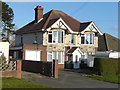
10
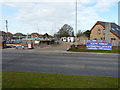
34, Canterbury Road
Planning permission has been approved, with conditions, by Folkestone and Hythe District Council under application number Y17/1586/SH for the “demolition of existing commercial unit and erection of a replacement commercial unit containing two one bedroom flats above, erection of six two bedroom semi-detached bungalow dwelling houses together with construction of new vehicular access and internal road and associated parking”
This used to be the site of a Image
Image: © John Baker
Taken: 13 Mar 2019
0.09 miles