IMAGES TAKEN NEAR TO
Capel-le-Ferne, FOLKESTONE, CT18 7HZ
Introduction
This page details the photographs taken nearby to CT18 7HZ by members of the Geograph project.
The Geograph project started in 2005 with the aim of publishing, organising and preserving representative images for every square kilometre of Great Britain, Ireland and the Isle of Man.

There are currently over 7.5m images from over14,400 individuals and you can help contribute to the project by visiting https://www.geograph.org.uk
Image Map
Images are licensed for reuse under creativecommons.org/licenses/by-sa/2.0
Notes
- Clicking on the map will re-center to the selected point.
- The higher the marker number, the further away the image location is from the centre of the postcode.
Image Listing (51 Images Found)
Images are licensed for reuse under creativecommons.org/licenses/by-sa/2.0
Image
Details
Distance
1
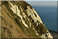
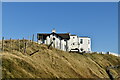
Cliff Top Path between Folkestone and Dover
For those walking the cliff path between Folkestone and Dover, this little section is the most vertigo inducing. It goes below the large white unnamed dwelling and hangs precariously over the railway line far far below. The railings were a jolly good idea.
Image: © Chris Heaton
Taken: 13 Sep 2010
0.01 miles
2
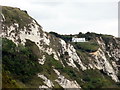
Abbot's Cliff
House on Abbot's Cliff seen from Folkestone Warren.
Image: © Helmut Zozmann
Taken: 13 Jul 2011
0.01 miles
4
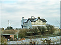
Houses on the cliff
Most prominent is Clement House, with the rather cleaner white Abbotscliff House beyond.
Image: © Robin Webster
Taken: 16 Jan 2013
0.02 miles
6
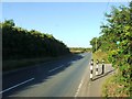
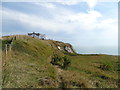
North Downs Way turns near New Dover Road
The long distance path from Dover, heads via a cliff top path (via Shakespeare Cliff and Abbot's Cliff) towards Capel-le-Ferne. It turns left to follow another cliff top path above The Warren (nature reserve).
Image: © David Anstiss
Taken: 27 Feb 2011
0.04 miles
7
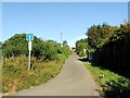
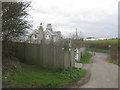
Lane leading from New Dover Road to the North Downs Way
Image: © Chris Whippet
Taken: 8 Aug 2015
0.05 miles
8
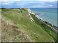
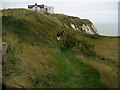
Cliff top above Folkestone Warren
A zig-zag path descends the cliffs of Folkestone Warren beneath the Cliff Top Cafe. The path then follows the railway line eastwards before ascending rapidly again via steps to a caravan park. This view is near the top of the steps and looks along the chalk cliffs towards Samphire Hoe, with the railway line at the foot. Both the North Downs Way and the Saxon Shore Way follow the top of the cliffs. The cliffs of Folkestone Warren consist of a series of landslides, and have probably been more intensively studied than any other landslide of comparable size in Great Britain. This is largely because it is crossed by the main Folkestone-Dover railway line, which on occasion has been displaced by slipping. This has created an immediate demand for detailed studies and monitoring. The site has suffered twelve major slips since 1765, and is now protected by complex coastal defence works.
Image: © Marathon
Taken: 8 Aug 2011
0.06 miles