IMAGES TAKEN NEAR TO
Winehouse Lane, FOLKESTONE, CT18 7HU
Introduction
This page details the photographs taken nearby to Winehouse Lane, CT18 7HU by members of the Geograph project.
The Geograph project started in 2005 with the aim of publishing, organising and preserving representative images for every square kilometre of Great Britain, Ireland and the Isle of Man.

There are currently over 7.5m images from over14,400 individuals and you can help contribute to the project by visiting https://www.geograph.org.uk
Image Map
Images are licensed for reuse under creativecommons.org/licenses/by-sa/2.0
Notes
- Clicking on the map will re-center to the selected point.
- The higher the marker number, the further away the image location is from the centre of the postcode.
Image Listing (85 Images Found)
Images are licensed for reuse under creativecommons.org/licenses/by-sa/2.0
Image
Details
Distance
2
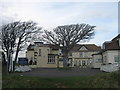
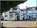
The Lighthouse Inn, Capel-le-Ferne
Bar, restaurant and guest house on Old Dover Road, near Winehouse Lane.
Image: © David Anstiss
Taken: 27 Feb 2011
0.04 miles
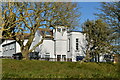
3

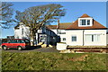
Electrical substation, Winehouse Lane, Capel-le-Ferne
Operated by UK Power Networks
Image: © Tim Heaton
Taken: 8 Aug 2019
0.04 miles
8
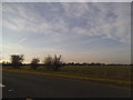
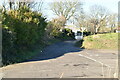
Fields by New Dover Road, Capel-le-Ferne
Image: © David Howard
Taken: 10 Apr 2016
0.07 miles
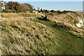
9
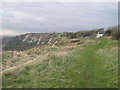
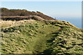
North Downs Way on East Cliffs
The long distance path leads along a cliff top path beside Old Dover Road, towards Capel-le-Ferne. On the left the railway leads towards Folkestone (from Dover via the Warren).
Image: © David Anstiss
Taken: 27 Feb 2011
0.07 miles