IMAGES TAKEN NEAR TO
Green Lane, FOLKESTONE, CT18 7HD
Introduction
This page details the photographs taken nearby to Green Lane, CT18 7HD by members of the Geograph project.
The Geograph project started in 2005 with the aim of publishing, organising and preserving representative images for every square kilometre of Great Britain, Ireland and the Isle of Man.

There are currently over 7.5m images from over14,400 individuals and you can help contribute to the project by visiting https://www.geograph.org.uk
Image Map
Images are licensed for reuse under creativecommons.org/licenses/by-sa/2.0
Notes
- Clicking on the map will re-center to the selected point.
- The higher the marker number, the further away the image location is from the centre of the postcode.
Image Listing (25 Images Found)
Images are licensed for reuse under creativecommons.org/licenses/by-sa/2.0
Image
Details
Distance
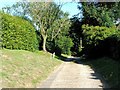
5
Bridleway to Cauldham Lane
Green Lane (track) leads from Capel Street through a field towards the lane.
Image: © David Anstiss
Taken: 27 Feb 2011
0.07 miles
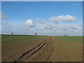
6
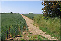
Path to Cauldham Lane
The path is an extension of Green Lane in Capel-le-Ferne and continues through this field of wheat. The Channel Tunnel passes under this point.
Image: © Stephen McKay
Taken: 16 Jun 2023
0.07 miles