IMAGES TAKEN NEAR TO
Uphill, FOLKESTONE, CT18 7FG
Introduction
This page details the photographs taken nearby to Uphill, CT18 7FG by members of the Geograph project.
The Geograph project started in 2005 with the aim of publishing, organising and preserving representative images for every square kilometre of Great Britain, Ireland and the Isle of Man.

There are currently over 7.5m images from over14,400 individuals and you can help contribute to the project by visiting https://www.geograph.org.uk
Image Map
Images are licensed for reuse under creativecommons.org/licenses/by-sa/2.0
Notes
- Clicking on the map will re-center to the selected point.
- The higher the marker number, the further away the image location is from the centre of the postcode.
Image Listing (75 Images Found)
Images are licensed for reuse under creativecommons.org/licenses/by-sa/2.0
Image
Details
Distance
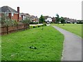
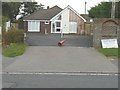
2
Uphill, Hawkinge
This road was probably named in remembrance of the hamlet of Uphill, which was no more than a mile square in area. It became officially part of Hawkinge parish on 25 March 1886.
Image: © John Baker
Taken: 1 Mar 2015
0.07 miles
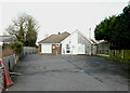
5
Hawkinge and Elham Valley Practice, Canterbury Road
As well as bearing the title of this image, the notice-board also bears the words “refurbishment and extension to Hawkinge Health Centre completed 2013”. In the past, there used to a Portakabin in front of the main building.
Image: © John Baker
Taken: 10 Aug 2014
0.12 miles
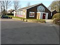
6
Hawkinge & Elham Valley Practice, 74 Canterbury Road
Image: © John Baker
Taken: 6 Feb 2022
0.12 miles
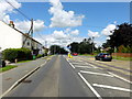
7
St Luke?s church, Canterbury Road
It was built in 1958 to replace a church clad in corrugated tin sheeting, that had been erected in 1889 and had been damaged by a fire, which had partially destroyed the front of the building. The church is located next door and to the left of Image
Image: © John Baker
Taken: 1 Mar 2015
0.12 miles
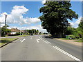
8

St Luke's Church, Hawkinge
The Parish Church of Hawkinge. On A260 Canterbury Road.
Image: © David Anstiss
Taken: 31 Jan 2009
0.13 miles
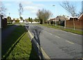
9
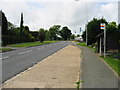
View along Canterbury Road towards Hawkinge
Image: © Nick Smith
Taken: 20 Jun 2008
0.13 miles
10

Post office store and community centre, Hawkinge
Image: © Nick Smith
Taken: 20 Jun 2008
0.14 miles