IMAGES TAKEN NEAR TO
Crete Road East, FOLKESTONE, CT18 7EG
Introduction
This page details the photographs taken nearby to Crete Road East, CT18 7EG by members of the Geograph project.
The Geograph project started in 2005 with the aim of publishing, organising and preserving representative images for every square kilometre of Great Britain, Ireland and the Isle of Man.

There are currently over 7.5m images from over14,400 individuals and you can help contribute to the project by visiting https://www.geograph.org.uk
Image Map
Images are licensed for reuse under creativecommons.org/licenses/by-sa/2.0
Notes
- Clicking on the map will re-center to the selected point.
- The higher the marker number, the further away the image location is from the centre of the postcode.
Image Listing (44 Images Found)
Images are licensed for reuse under creativecommons.org/licenses/by-sa/2.0
Image
Details
Distance
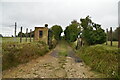
1
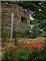
Yet another Pill Box
Eastern wall of a pill box. Relic from World War 2 with some nicely placed poppies.
Image: © Dennis simpson
Taken: 29 May 2011
0.03 miles
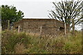
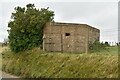
3
Pillbox on Crete Road East
A concrete World War II observation post/bunker on the lane above Folkestone.
Image: © David Anstiss
Taken: 27 Feb 2011
0.03 miles
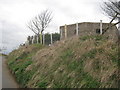
6
Pillbox on Crete Road East (2)
A concrete World War II observation post/bunker on the lane above Folkestone.
Now, a feature in a garden!
Image: © David Anstiss
Taken: 27 Feb 2011
0.04 miles

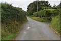
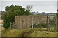
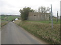
10
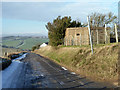
Pillbox by Crete Road East
The untreated lane was rather slippery on a cold day.
Image: © Robin Webster
Taken: 16 Jan 2013
0.08 miles