IMAGES TAKEN NEAR TO
Millfield, FOLKESTONE, CT18 7DQ
Introduction
This page details the photographs taken nearby to Millfield, CT18 7DQ by members of the Geograph project.
The Geograph project started in 2005 with the aim of publishing, organising and preserving representative images for every square kilometre of Great Britain, Ireland and the Isle of Man.

There are currently over 7.5m images from over14,400 individuals and you can help contribute to the project by visiting https://www.geograph.org.uk
Image Map
Images are licensed for reuse under creativecommons.org/licenses/by-sa/2.0
Notes
- Clicking on the map will re-center to the selected point.
- The higher the marker number, the further away the image location is from the centre of the postcode.
Image Listing (11 Images Found)
Images are licensed for reuse under creativecommons.org/licenses/by-sa/2.0
Image
Details
Distance
1
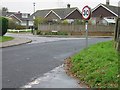
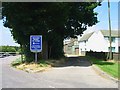
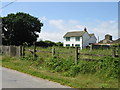
Junction of Stombers Lane and Cowgate Lane
With Fernfield to the left.
Image: © Nick Smith
Taken: 13 Nov 2007
0.14 miles
2
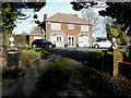
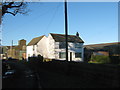
Fernlea, The Street, Hawkinge
Planning permission has been approved, with conditions, by Folkestone and Hythe District Council under application number Y19/1440/FH for an “outline application to replace existing detached dwelling with 2 new detached dwellings”.
Image: © John Baker
Taken: 1 Mar 2020
0.17 miles
3
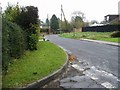
View along Cowgate Lane from Stombers Lane junction
Image: © Nick Smith
Taken: 13 Nov 2007
0.18 miles
4
Land Adjoining 45, The Street
Planning permission has been approved, with conditions, by Folkestone and Hythe District Council under application number 22/0268/FH for the “erection of a 2 storey, 4 bedroom detached dwelling with garage and formation of new access and associated landscaping”.
Image: © John Baker
Taken: 23 Jul 2022
0.19 miles
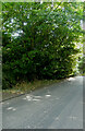
5
Fernfield Farm and access road to the A260
Image: © Nick Smith
Taken: 28 Jun 2008
0.21 miles
6
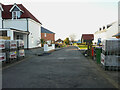
Windmill Close, Mill Lane, Hawkinge
This was Image in March 2020.
Image: © John Baker
Taken: 9 Jan 2022
0.22 miles
7
Windmill Close, Mill Lane, Hawkinge
Planning permission has been approved, with conditions, by Folkestone and Hythe District Council under application number Y18/0555/FH for the “erection of a residential development of 14 houses with associated access being details pursuant to outline planning permission Y15/0741/SH (details relating to appearance, landscaping, layout and scale) resubmission of planning application Y17/1050/SH, together with discharging planning conditions 8, 17 and 24”.
The houses are being built on land which was sold by Mill Farm, Mill Lane, Hawkinge to a developer.
Image: © John Baker
Taken: 1 Mar 2020
0.23 miles
8
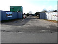
Access road to the A260 (but not for motorcycles!)
Image: © Nick Smith
Taken: 28 Jun 2008
0.23 miles
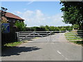
10
Fernfield Farm
On Farnfield Lane near Hawkinge.
Image: © David Anstiss
Taken: 9 Jan 2011
0.24 miles