IMAGES TAKEN NEAR TO
St. Johns Close, FOLKESTONE, CT18 7DP
Introduction
This page details the photographs taken nearby to St. Johns Close, CT18 7DP by members of the Geograph project.
The Geograph project started in 2005 with the aim of publishing, organising and preserving representative images for every square kilometre of Great Britain, Ireland and the Isle of Man.

There are currently over 7.5m images from over14,400 individuals and you can help contribute to the project by visiting https://www.geograph.org.uk
Image Map
Images are licensed for reuse under creativecommons.org/licenses/by-sa/2.0
Notes
- Clicking on the map will re-center to the selected point.
- The higher the marker number, the further away the image location is from the centre of the postcode.
Image Listing (21 Images Found)
Images are licensed for reuse under creativecommons.org/licenses/by-sa/2.0
Image
Details
Distance
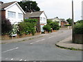
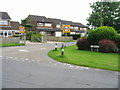
2
View along Pay Street from junction with St John's Way
Image: © Nick Smith
Taken: 20 Jun 2008
0.04 miles
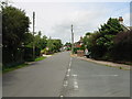
6
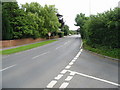
Looking SE along the A260 Canterbury Road towards Hawkinge
Image: © Nick Smith
Taken: 20 Jun 2008
0.06 miles
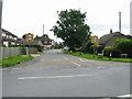
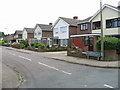
8
View W along Coach Road and crossroads with Pay Street
Image: © Nick Smith
Taken: 20 Jun 2008
0.10 miles
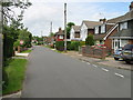
9
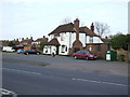
The Black Horse
Standing on a bend in the A260 at Densole.
Image: © Jonathan Billinger
Taken: 25 Apr 2007
0.11 miles
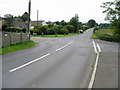
10
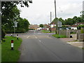
Crossroads of Pay Street and Coach Road
Both join the A260 Canterbury Road
Image: © Nick Smith
Taken: 20 Jun 2008
0.12 miles