IMAGES TAKEN NEAR TO
Clarendon Street, DOVER, CT17 9UP
Introduction
This page details the photographs taken nearby to Clarendon Street, CT17 9UP by members of the Geograph project.
The Geograph project started in 2005 with the aim of publishing, organising and preserving representative images for every square kilometre of Great Britain, Ireland and the Isle of Man.

There are currently over 7.5m images from over14,400 individuals and you can help contribute to the project by visiting https://www.geograph.org.uk
Image Map
Images are licensed for reuse under creativecommons.org/licenses/by-sa/2.0
Notes
- Clicking on the map will re-center to the selected point.
- The higher the marker number, the further away the image location is from the centre of the postcode.
Image Listing (177 Images Found)
Images are licensed for reuse under creativecommons.org/licenses/by-sa/2.0
Image
Details
Distance
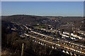
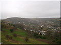
5
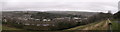
Panorama of Dover
As seen from Image
Looking across the views over Dover.
On the right is Dover Railway Station.
Image: © David Anstiss
Taken: 26 Dec 2012
0.07 miles
6
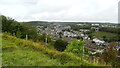
Clarendon area of Dover from Drop Redoubt
Image: © Colin Park
Taken: 22 Sep 2019
0.07 miles
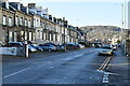
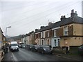
8

Clarendon Place
A long straight road with terraced houses to both sides.
Image: © Oast House Archive
Taken: 5 Aug 2010
0.07 miles
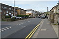
9
View of Clarendon, Dover
As seen from Image
Clarendon is one of the housing suburbs of Dover.
Coney Hill (part of Stepping Down) is on the left.
Image: © David Anstiss
Taken: 26 Dec 2012
0.07 miles