IMAGES TAKEN NEAR TO
Folkestone Road, DOVER, CT17 9SJ
Introduction
This page details the photographs taken nearby to Folkestone Road, CT17 9SJ by members of the Geograph project.
The Geograph project started in 2005 with the aim of publishing, organising and preserving representative images for every square kilometre of Great Britain, Ireland and the Isle of Man.

There are currently over 7.5m images from over14,400 individuals and you can help contribute to the project by visiting https://www.geograph.org.uk
Image Map (Loading...)


Getting Data...Please wait
Leaflet Map data © OpenStreetMap
Images are licensed for reuse under creativecommons.org/licenses/by-sa/2.0
Notes
- Clicking on the map will re-center to the selected point.
- The higher the marker number, the further away the image location is from the centre of the postcode.
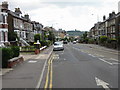
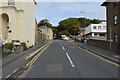
Image Listing (81 Images Found)
Images are licensed for reuse under creativecommons.org/licenses/by-sa/2.0
Image
Details
Distance
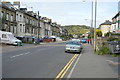
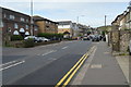
3
View along the B2011 Folkestone Road towards Dover
Image: © Nick Smith
Taken: 20 Jul 2008
0.03 miles
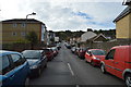
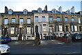
7
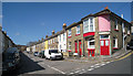
Winchelsea Street, Dover
A quiet traditional Victorian terrace. A converted pub on the corner with Winchelsea Road. At the end of the road is an entrance to Vale View Community School and Nursery.
Image: © Oast House Archive
Taken: 8 Apr 2010
0.06 miles