IMAGES TAKEN NEAR TO
Elm Park Gardens, DOVER, CT17 9NQ
Introduction
This page details the photographs taken nearby to Elm Park Gardens, CT17 9NQ by members of the Geograph project.
The Geograph project started in 2005 with the aim of publishing, organising and preserving representative images for every square kilometre of Great Britain, Ireland and the Isle of Man.

There are currently over 7.5m images from over14,400 individuals and you can help contribute to the project by visiting https://www.geograph.org.uk
Image Map
Images are licensed for reuse under creativecommons.org/licenses/by-sa/2.0
Notes
- Clicking on the map will re-center to the selected point.
- The higher the marker number, the further away the image location is from the centre of the postcode.
Image Listing (15 Images Found)
Images are licensed for reuse under creativecommons.org/licenses/by-sa/2.0
Image
Details
Distance
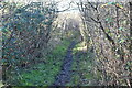
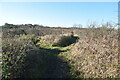
4
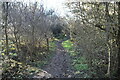
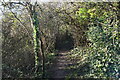
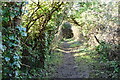
Path down Stepping Down
Dover Castle on the horizon
Image: © Tim Heaton
Taken: 8 Aug 2019
0.14 miles
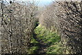
5
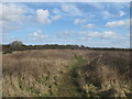
Footpath on Coney Hill
A footpath leads from Church Hougham towards Dover via this scrub land hill. In the background are trees on Stepping Down close to Maxton,a suburb of Dover.
Image: © David Anstiss
Taken: 27 Feb 2011
0.14 miles
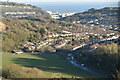
10
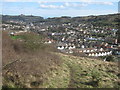
View of Dover
As seen from a footpath on Stepping Down. Looking towards Dover Docks.
Dover Castle is on the left and the Western Heights are on the right.
Image: © David Anstiss
Taken: 27 Feb 2011
0.17 miles