IMAGES TAKEN NEAR TO
St. Davids Avenue, DOVER, CT17 9JS
Introduction
This page details the photographs taken nearby to St. Davids Avenue, CT17 9JS by members of the Geograph project.
The Geograph project started in 2005 with the aim of publishing, organising and preserving representative images for every square kilometre of Great Britain, Ireland and the Isle of Man.

There are currently over 7.5m images from over14,400 individuals and you can help contribute to the project by visiting https://www.geograph.org.uk
Image Map
Images are licensed for reuse under creativecommons.org/licenses/by-sa/2.0
Notes
- Clicking on the map will re-center to the selected point.
- The higher the marker number, the further away the image location is from the centre of the postcode.
Image Listing (117 Images Found)
Images are licensed for reuse under creativecommons.org/licenses/by-sa/2.0
Image
Details
Distance
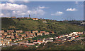
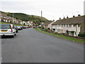
1
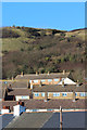
The rooftops of Aycliff
From the eastern end of St David's Avenue
Image: © Nick Smith
Taken: 14 Oct 2009
0.03 miles
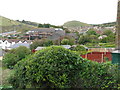
4
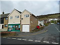
Aycliff post office and stores
Situated on the corner of Old Folkestone Road and St Giles Road.
Image: © Jonathan Billinger
Taken: 27 Mar 2008
0.06 miles
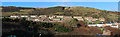
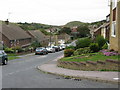
5
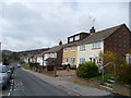
St David's Avenue, Aycliff
View west towards Folkestone.
Image: © Jonathan Billinger
Taken: 27 Mar 2008
0.06 miles
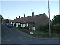
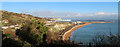
9
St David's Avenue from junction with St George's Crescent
Image: © Nick Smith
Taken: 14 Oct 2009
0.10 miles