IMAGES TAKEN NEAR TO
Northampton Quay, CT17 9FP
Introduction
This page details the photographs taken nearby to Northampton Quay, CT17 9FP by members of the Geograph project.
The Geograph project started in 2005 with the aim of publishing, organising and preserving representative images for every square kilometre of Great Britain, Ireland and the Isle of Man.

There are currently over 7.5m images from over14,400 individuals and you can help contribute to the project by visiting https://www.geograph.org.uk
Image Map
Images are licensed for reuse under creativecommons.org/licenses/by-sa/2.0
Notes
- Clicking on the map will re-center to the selected point.
- The higher the marker number, the further away the image location is from the centre of the postcode.
Image Listing (1480 Images Found)
Images are licensed for reuse under creativecommons.org/licenses/by-sa/2.0
Image
Details
Distance
2
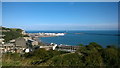
Dover - 2014
Dover, Kent, Western Heights, Drop Redoubt Fort, Port of Dover, Eastern Docks visible in the distance
Image: © Robert Zozmann
Taken: 5 Oct 2014
0.02 miles
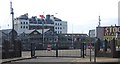
3
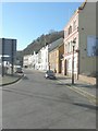
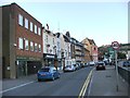
Backs of houses on Snargate Street, Dover
Image: © David Howard
Taken: 10 Apr 2016
0.03 miles
4
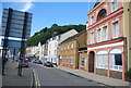
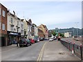
Snargate St
A small street running parallel to the A20.
Image: © N Chadwick
Taken: 28 Aug 2011
0.03 miles
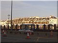
7
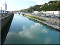
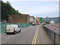
Wellington Dock
Hoarding, in connection with the Dover Western Docks Revival Scheme, had been erected, at the far end of the carpark on Northampton Quay, to contain blocks of concrete, which had been broken up.
Image: © John Baker
Taken: 22 Sep 2017
0.03 miles