IMAGES TAKEN NEAR TO
Elizabeth Street, DOVER, CT17 9FE
Introduction
This page details the photographs taken nearby to Elizabeth Street, CT17 9FE by members of the Geograph project.
The Geograph project started in 2005 with the aim of publishing, organising and preserving representative images for every square kilometre of Great Britain, Ireland and the Isle of Man.

There are currently over 7.5m images from over14,400 individuals and you can help contribute to the project by visiting https://www.geograph.org.uk
Image Map (Loading...)


Getting Data...Please wait
Leaflet Map data © OpenStreetMap
Images are licensed for reuse under creativecommons.org/licenses/by-sa/2.0
Notes
- Clicking on the map will re-center to the selected point.
- The higher the marker number, the further away the image location is from the centre of the postcode.
Image Listing (416 Images Found)
Images are licensed for reuse under creativecommons.org/licenses/by-sa/2.0
Image
Details
Distance
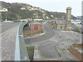
1
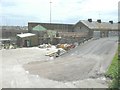
Alterations to the Old Harbour Station, Elizabeth Street
Seen from The Viaduct. Planning permission has been granted by Dover District Council under application numbers DOV/13/00729 and DOV/13/00730 for the “alterations of storage building and covered area to form new two storey office and opening up of existing bricked up windows and installation of new windows”.
Image: © John Baker
Taken: 23 May 2014
0.01 miles
2
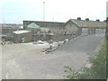
Progress of the alterations to the Old Harbour Station, Elizabeth Street
Seen from The Viaduct and compared with Image, taken on 23 May 2014, work is progressing slowly but the new windows mentioned in the planning application can be seen. Planning permission has been granted by Dover District Council under application numbers DOV/13/00729 and DOV/13/00730 for the “alterations of storage building and covered area to form new two storey office and opening up of existing bricked up windows and installation of new windows”.
Image: © John Baker
Taken: 29 Aug 2014
0.01 miles
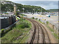
3
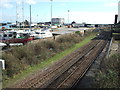
Dover Harbour railway station (site), Kent
Opened in 1861 by the London, Chatham and Dover Railway and used until 1927 by which time it had been largely superseded by Dover Marine/Western Docks in the background. View south.
Image: © Nigel Thompson
Taken: 3 Mar 2007
0.01 miles
4
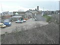
Alterations to the Old Harbour Railway Station, Elizabeth Road
Seen from The Viaduct. Planning permission has been granted by Dover District Council under application numbers DOV/13/00729 and DOV/13/00730 for the “alterations of storage building and covered area to form new two storey office and opening up of existing bricked up windows and installation of new windows”.
Image: © John Baker
Taken: 10 Jan 2014
0.02 miles
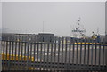
6
Fence between the railway and the marina
Image: © N Chadwick
Taken: 28 Aug 2011
0.03 miles
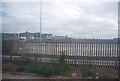
7
Railway to Dover
This railway runs to Dover Priory Station from Folkestone. Seen from The Viaduct roadbridge.
Image: © David Anstiss
Taken: 2 May 2009
0.03 miles
8
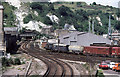
Shunting Dover Western Docks
Ferry wagons being shunted at the docks by a Class 09 locomotive in the shadow of the white cliffs. Rail access to the docks finally ceased in 1995 with the closure of the signal box and the tracks were lifted in 1996.
Image: © Martin Addison
Taken: Unknown
0.03 miles
9

Former Dover Harbour Station
Grade II listed. https://www.britishlistedbuildings.co.uk/101273166-former-dover-harbour-station-dover
Image: © N Chadwick
Taken: 15 Feb 2018
0.03 miles
10
Dover Harbour Station
Seen from The Viaduct. To the station’s left a Southern Water building had scaffolding erected up to its roof. Perhaps this was so the accumulation of moss on the roof could be removed.
Image: © John Baker
Taken: 26 Dec 2014
0.03 miles