IMAGES TAKEN NEAR TO
Knights Templars, DOVER, CT17 9DX
Introduction
This page details the photographs taken nearby to Knights Templars, CT17 9DX by members of the Geograph project.
The Geograph project started in 2005 with the aim of publishing, organising and preserving representative images for every square kilometre of Great Britain, Ireland and the Isle of Man.

There are currently over 7.5m images from over14,400 individuals and you can help contribute to the project by visiting https://www.geograph.org.uk
Image Map
Images are licensed for reuse under creativecommons.org/licenses/by-sa/2.0
Notes
- Clicking on the map will re-center to the selected point.
- The higher the marker number, the further away the image location is from the centre of the postcode.
Image Listing (307 Images Found)
Images are licensed for reuse under creativecommons.org/licenses/by-sa/2.0
Image
Details
Distance
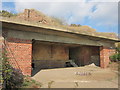
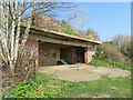
5
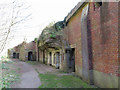
Rear of WWII gun emplacements at the Western Heights, Dover
Image: © Gareth James
Taken: 30 Mar 2019
0.05 miles
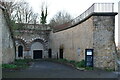
7
St Martin's Battery, Great Western Heights
One of the three concrete gun emplacements on the cliffs above Dover docks.
Image: © David Anstiss
Taken: 26 Dec 2012
0.06 miles
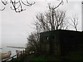
8
WWII gun defence at the Western Heights, Dover
Image: © Gareth James
Taken: 30 Mar 2019
0.06 miles
9
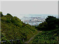
Panoramic view from Western Heights
Work was still progressing on a new marina outer wave wall just beyond the seaward end of the Marina Pier (which is at the centre-left of the view).
Image: © John Baker
Taken: 10 Sep 2022
0.07 miles