IMAGES TAKEN NEAR TO
Military Road, DOVER, CT17 9BH
Introduction
This page details the photographs taken nearby to Military Road, CT17 9BH by members of the Geograph project.
The Geograph project started in 2005 with the aim of publishing, organising and preserving representative images for every square kilometre of Great Britain, Ireland and the Isle of Man.

There are currently over 7.5m images from over14,400 individuals and you can help contribute to the project by visiting https://www.geograph.org.uk
Image Map
Images are licensed for reuse under creativecommons.org/licenses/by-sa/2.0
Notes
- Clicking on the map will re-center to the selected point.
- The higher the marker number, the further away the image location is from the centre of the postcode.
Image Listing (1173 Images Found)
Images are licensed for reuse under creativecommons.org/licenses/by-sa/2.0
Image
Details
Distance
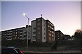
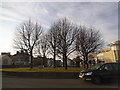
6
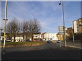
Folkestone Road at the junction of York Street
Image: © David Howard
Taken: 10 Apr 2016
0.03 miles
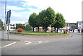
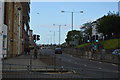
7
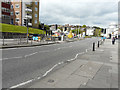
Roadworks, York Street
It appeared that a new lamppost was being installed near to the roundabout.
Image: © John Baker
Taken: 28 Apr 2017
0.04 miles