IMAGES TAKEN NEAR TO
Durham Close, DOVER, CT17 9BD
Introduction
This page details the photographs taken nearby to Durham Close, CT17 9BD by members of the Geograph project.
The Geograph project started in 2005 with the aim of publishing, organising and preserving representative images for every square kilometre of Great Britain, Ireland and the Isle of Man.

There are currently over 7.5m images from over14,400 individuals and you can help contribute to the project by visiting https://www.geograph.org.uk
Image Map
Images are licensed for reuse under creativecommons.org/licenses/by-sa/2.0
Notes
- Clicking on the map will re-center to the selected point.
- The higher the marker number, the further away the image location is from the centre of the postcode.
Image Listing (1307 Images Found)
Images are licensed for reuse under creativecommons.org/licenses/by-sa/2.0
Image
Details
Distance
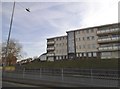
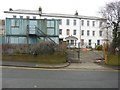
4
Prince of Wales House, Durham Hill
It would seem that scaffolding has been erected, on the left hand side, to enable repairs to be made to the chimney.
Image: © John Baker
Taken: 10 Jan 2014
0.04 miles
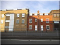
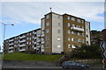
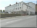
6
Durham Hill
On the left hand side, the terrace of three dwellings, built in a light-coloured brick, are known as 1-3 Mount Pleasant, while the dwellings beyond are known as 1-7 Bowling Green Terrace. The building opposite is Edinburgh House.
Image: © John Baker
Taken: 23 Aug 2013
0.04 miles
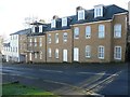
9
Prince of Wales House, Princes Street
Planning permission has been granted by Dover District Council under application numbers DOV/96/00858 a "change of use and alterations to YMCA Hostel and community centre", DOV/04/0939 the "demolition of an unlisted building in a conservation area" and DOV/04/00938 the "part conversion and part demolition of existing building and construction of new building to create 35
flats".
It would seem that application number DOV/04/00938 was the planning permission adopted.
Image: © John Baker
Taken: 1 Mar 2013
0.05 miles
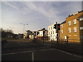
10
Prince of Wales House, Princes Street
Seen from Durham Hill, an extension is being built using breeze blocks.
Image: © John Baker
Taken: 1 Aug 2014
0.05 miles