IMAGES TAKEN NEAR TO
Dourside, DOVER, CT17 0UX
Introduction
This page details the photographs taken nearby to Dourside, CT17 0UX by members of the Geograph project.
The Geograph project started in 2005 with the aim of publishing, organising and preserving representative images for every square kilometre of Great Britain, Ireland and the Isle of Man.

There are currently over 7.5m images from over14,400 individuals and you can help contribute to the project by visiting https://www.geograph.org.uk
Image Map
Images are licensed for reuse under creativecommons.org/licenses/by-sa/2.0
Notes
- Clicking on the map will re-center to the selected point.
- The higher the marker number, the further away the image location is from the centre of the postcode.
Image Listing (39 Images Found)
Images are licensed for reuse under creativecommons.org/licenses/by-sa/2.0
Image
Details
Distance
1
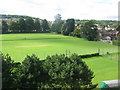
Crabble playing fields
Taken from the Crabble corn mill.
Image: © Nick Smith
Taken: 9 Sep 2010
0.01 miles
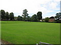
3
Lower Road and the mill stream at Crabble
Image: © Nick Smith
Taken: 9 Sep 2010
0.03 miles
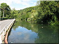
4
Lower Road Bridge over River Dour
Lower Road leads from Kearsney towards central Dover.
The river leads from Kearsney through Dover towards the sea. It leads under the road towards Image
Image: © David Anstiss
Taken: 6 Mar 2011
0.05 miles
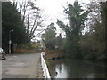
5
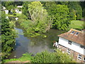
Millpond for Crabble Mill
Fed by the River Dour.
Image: © Nick Smith
Taken: 9 Sep 2010
0.05 miles
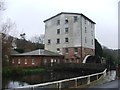
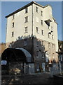
7
Crabble water mill
The current structure was built in 1812 but there are records to show there was a mill on this site as far back as 1227, see http://www.ccmt.org.uk/ for more info.
Image: © Nick Smith
Taken: 9 Sep 2010
0.07 miles
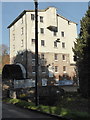
8
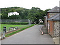
Access road for Crabble Mill car park
The mill is the white building in the trees.
Image: © Nick Smith
Taken: 9 Sep 2010
0.07 miles
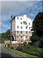
9
Crabble Corn Mill, Lower Road, River
This is a Grade II listed, early 19th century building. It ceased to operate in 1893 and was sold in 1957. It was then bought by the Cleary Foundation in 1972 who restored it. But it became neglected until the Crabble Corn Mill Trust set up in 1987. It opened to the public in 1990, mainly on Sundays in the summer season for tours, guided and self-guided. It is one of the most complete and working examples of a Georgian watermill in Europe.
Image: © pam fray
Taken: 4 Dec 2018
0.07 miles
10
Crabble Corn Mill, Lower Road, River
This is a Grade II listed, early 19th century building. It ceased to operate in 1893 and was sold in 1957. It was then bought by the Cleary Foundation in 1972 who restored it. But it became neglected until the Crabble Corn Mill Trust was set up in 1987. It opened to the public in 1990, mainly on Sundays in the summer season for tours, guided and self-guided. It is one of the most complete and working examples of a Georgian watermill in Europe.
Image: © pam fray
Taken: 4 Dec 2018
0.07 miles