IMAGES TAKEN NEAR TO
Mill Race, DOVER, CT17 0UR
Introduction
This page details the photographs taken nearby to Mill Race, CT17 0UR by members of the Geograph project.
The Geograph project started in 2005 with the aim of publishing, organising and preserving representative images for every square kilometre of Great Britain, Ireland and the Isle of Man.

There are currently over 7.5m images from over14,400 individuals and you can help contribute to the project by visiting https://www.geograph.org.uk
Image Map
Images are licensed for reuse under creativecommons.org/licenses/by-sa/2.0
Notes
- Clicking on the map will re-center to the selected point.
- The higher the marker number, the further away the image location is from the centre of the postcode.
Image Listing (55 Images Found)
Images are licensed for reuse under creativecommons.org/licenses/by-sa/2.0
Image
Details
Distance
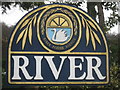
6
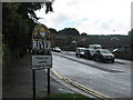
River Village Sign
On Crabble Road leading towards River.
Image: © David Anstiss
Taken: 14 Aug 2010
0.08 miles
7
Close-up River Village Sign
Seen in Image, in context.
Image: © David Anstiss
Taken: 6 Mar 2011
0.08 miles
8
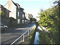
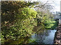
Lower Road, Crabble
Crabble Court is the large building beyond the nearest house, which is known as The Old Vicarage. The River Dour flows beside Lower Road.
Image: © John Baker
Taken: 18 Nov 2012
0.08 miles