IMAGES TAKEN NEAR TO
Cowper Road, DOVER, CT17 0PG
Introduction
This page details the photographs taken nearby to Cowper Road, CT17 0PG by members of the Geograph project.
The Geograph project started in 2005 with the aim of publishing, organising and preserving representative images for every square kilometre of Great Britain, Ireland and the Isle of Man.

There are currently over 7.5m images from over14,400 individuals and you can help contribute to the project by visiting https://www.geograph.org.uk
Image Map
Images are licensed for reuse under creativecommons.org/licenses/by-sa/2.0
Notes
- Clicking on the map will re-center to the selected point.
- The higher the marker number, the further away the image location is from the centre of the postcode.
Image Listing (10 Images Found)
Images are licensed for reuse under creativecommons.org/licenses/by-sa/2.0
Image
Details
Distance
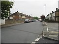
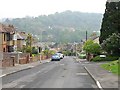
2
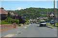
Minnis Lane, River
A rural lane that widens out as it descends into the suburban valley.
Image: © Robin Webster
Taken: 15 Jun 2019
0.19 miles
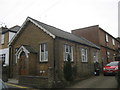
4
River Methodist Church
As seen from Lewisham Road.
Image: © David Anstiss
Taken: 6 Mar 2011
0.20 miles
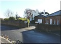
5
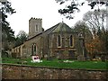
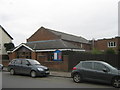
River Methodist Church Hall
As seen from Common Lane. This church hall (currently used by a playgroup) is linked to the main church (in the background). See also Image
Image: © David Anstiss
Taken: 6 Mar 2011
0.20 miles
9
River House, Valley Road, River
River House was built and opened in 1793 as the River Workhouse.
Image: © John Baker
Taken: 18 Nov 2012
0.23 miles