IMAGES TAKEN NEAR TO
Barwick Road, DOVER, CT17 0LH
Introduction
This page details the photographs taken nearby to Barwick Road, CT17 0LH by members of the Geograph project.
The Geograph project started in 2005 with the aim of publishing, organising and preserving representative images for every square kilometre of Great Britain, Ireland and the Isle of Man.

There are currently over 7.5m images from over14,400 individuals and you can help contribute to the project by visiting https://www.geograph.org.uk
Image Map
Images are licensed for reuse under creativecommons.org/licenses/by-sa/2.0
Notes
- Clicking on the map will re-center to the selected point.
- The higher the marker number, the further away the image location is from the centre of the postcode.
Image Listing (11 Images Found)
Images are licensed for reuse under creativecommons.org/licenses/by-sa/2.0
Image
Details
Distance
1
St Radigund's part of Dover
Foot path gate to Coombe Down on the edges of Dover.
https://en.wikipedia.org/wiki/Dover
Image: © James Emmans
Taken: 13 Sep 2020
0.06 miles
2
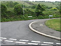
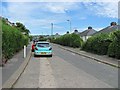
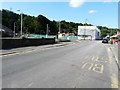
Junction of St Radigund's Road with Barwick Road
Image: © Nick Smith
Taken: 29 Apr 2007
0.09 miles
3
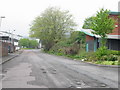
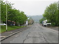
Looking W along Poulton Close
A fairly typical industrial estate road.
Image: © Nick Smith
Taken: 29 Apr 2007
0.10 miles
4
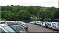
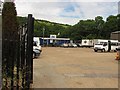
Car park, Coombe Valley Industrial Estate
An area of land used for long term parking in an industrial estate. Gorse Hill in the background.
Image: © Richard Webb
Taken: 13 Jul 2010
0.13 miles
5
Relyon car park
Long term parking for ferry passengers.
Image: © Richard Webb
Taken: 7 Jul 2010
0.19 miles
6
Beaufoy Road
Taken during a vicious diversion due to work being done on the railway bridge at Coombe Valley Road. The hills here are sharp.
Image: © Richard Webb
Taken: 7 Jul 2010
0.19 miles
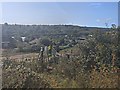
7
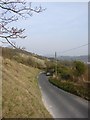
Gorse Hill
Taken along the bank adjacent to Barwick road, looking down towards Dover, with the Castle visible through the mist. Along the left is the CROW land on Gorse Hill, behind St Radigun’s, Dover. Elms Vale can be seen on the left.
Image: © Adam Hincks
Taken: 13 Apr 2007
0.22 miles
9
Looking southwest along Coombe Valley Road
Towards the former Buckland Hospital, which is encased in scaffolding and plastic sheeting.
Planning permission has been granted by Dover District Council under application number 17/00379 for the “demolition of building number five”. This image of Image is building number five in the application.
Image: © John Baker
Taken: 11 Aug 2017
0.23 miles
10
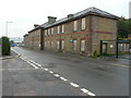
Part of the old Buckland Hospital, Coombe Valley Road
It was reported in the Kent Messenger on the 24 May 2016 that some of the former Buckland Hospital site, which extends to just over 4 acres, was to be sold at auction on 13 June at a freehold guide price of £300-320,000 by Clive Emson, property and land auctioneers http://www.cliveemson.co.uk/ but the website shows it was withdrawn prior to the auction. The premises opened in September 1836 as a workhouse and offered, up to 500 people in poverty, accommodation and employment opportunities. In 1948 it became a hospital with the launch of the NHS http://www.kentnews.co.uk/news/former_buckland_hospital_site_in_dover_to_be_sold_at_auction_next_month_1_4547278 This building has the words “Buckland Hospital” painted on the blue board!
Image: © John Baker
Taken: 19 Aug 2016
0.24 miles