IMAGES TAKEN NEAR TO
Crabble Meadows, DOVER, CT17 0FL
Introduction
This page details the photographs taken nearby to Crabble Meadows, CT17 0FL by members of the Geograph project.
The Geograph project started in 2005 with the aim of publishing, organising and preserving representative images for every square kilometre of Great Britain, Ireland and the Isle of Man.

There are currently over 7.5m images from over14,400 individuals and you can help contribute to the project by visiting https://www.geograph.org.uk
Image Map
Images are licensed for reuse under creativecommons.org/licenses/by-sa/2.0
Notes
- Clicking on the map will re-center to the selected point.
- The higher the marker number, the further away the image location is from the centre of the postcode.
Image Listing (138 Images Found)
Images are licensed for reuse under creativecommons.org/licenses/by-sa/2.0
Image
Details
Distance
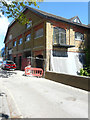
1
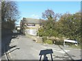
Alterations to Buckland Paper Mill, Crabble Hill
Planning permission was granted by Dover District Council under application number DOV/06/01455 for “mixed use development (new build and change of use) comprising detailed proposals (phase 1) for 141 residential units, retail (A1), offices (B1), cafe/restaurant bar (A4/A5), 'community hub' (D1/B1), open space, landscaping, parking and access and outline proposals (phases 1A, 2, 3 & 4) for up to 265 residential units, 80 bed nursing home and access - all other matters (layout, scale, appearance and landscaping) reserved”.
This view shows the latest ongoing building work, seen from Crabble Meadows.
Image: © John Baker
Taken: 26 May 2017
0.01 miles
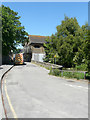
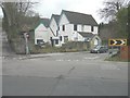
2
The Bull Inn, London Road, Buckland, Dover
With a small part of Buckland Paper Mill visible along Crabble Meadows
Image: © John Baker
Taken: 8 Feb 2011
0.01 miles
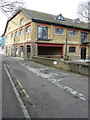
3
Alterations to Buckland Paper Mill, Crabble Hill
Viewed from Crabble Meadows, planning permission was granted by Dover District Council under application number DOV/06/01455 for “mixed use development (new build and change of use) comprising detailed proposals (phase 1) for 141 residential units, retail (A1), offices (B1), cafe/restaurant bar (A4/A5), 'community hub' (D1/B1), open space, landscaping, parking and access and outline proposals (phases 1A, 2, 3 & 4) for up to 265 residential units, 80 bed nursing home and access - all other matters (layout, scale, appearance and landscaping) reserved”.
Image: © John Baker
Taken: 12 May 2019
0.01 miles
4
Alterations to Buckland Paper Mill, Crabble Hill
Seen from Crabble Meadows, planning permission was granted by Dover District Council under application number DOV/06/01455 for “mixed use development (new build and change of use) comprising detailed proposals (phase 1) for 141 residential units, retail (A1), offices (B1), cafe/restaurant bar (A4/A5), 'community hub' (D1/B1), open space, landscaping, parking and access and outline proposals (phases 1A, 2, 3 & 4) for up to 265 residential units, 80 bed nursing home and access - all other matters (layout, scale, appearance and landscaping) reserved”.
This view shows these Image in May 2019.
Image: © John Baker
Taken: 2 Feb 2020
0.01 miles
5
Disused rectory of St Andrew?s Church, Crabble Meadows
Situated on the corner of Bunker’s Hill, the windows have been boarded over.
Image: © John Baker
Taken: 31 Jan 2014
0.02 miles
6
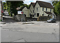
The rectory of St Andrew?s Church, Crabble Meadows
Compared with Image, the exterior has been freshly painted and a noticeboard has been erected, to the left of the entrance, which reads “Buckland Church of St Andrew”.
Image: © John Baker
Taken: 4 Sep 2015
0.02 miles
7
Alterations to Buckland Paper Mill, Crabble Hill
Viewed from Crabble Meadows, planning permission was granted by Dover District Council under application number DOV/06/01455 for “mixed use development (new build and change of use) comprising detailed proposals (phase 1) for 141 residential units, retail (A1), offices (B1), cafe/restaurant bar (A4/A5), 'community hub' (D1/B1), open space, landscaping, parking and access and outline proposals (phases 1A, 2, 3 & 4) for up to 265 residential units, 80 bed nursing home and access - all other matters (layout, scale, appearance and landscaping) reserved”.
This view shows these Image in February 2020. Work appears to be ongoing to the ground floor of the new building.
Image: © John Baker
Taken: 21 Nov 2020
0.02 miles
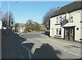
8
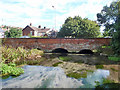
Buckland Bridge
London Road crosses the River Dour. This is just downstream of the former Buckland Paper Mill.
Image: © Robin Webster
Taken: 26 Sep 2015
0.02 miles
9
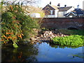
Buckland Bridge over the River Dour
Viewed from Crabble Meadows. It was built in 1795 and widened in the 20th century to carry the heavy traffic on London Road.
Image: © pam fray
Taken: 4 Dec 2018
0.02 miles
10
Crabble Meadows, Buckland, Dover
Showing part of the derelict Buckland Paper Mill
Image: © John Baker
Taken: 8 Feb 2011
0.02 miles