IMAGES TAKEN NEAR TO
Astor Avenue, DOVER, CT17 0AS
Introduction
This page details the photographs taken nearby to Astor Avenue, CT17 0AS by members of the Geograph project.
The Geograph project started in 2005 with the aim of publishing, organising and preserving representative images for every square kilometre of Great Britain, Ireland and the Isle of Man.

There are currently over 7.5m images from over14,400 individuals and you can help contribute to the project by visiting https://www.geograph.org.uk
Image Map
Images are licensed for reuse under creativecommons.org/licenses/by-sa/2.0
Notes
- Clicking on the map will re-center to the selected point.
- The higher the marker number, the further away the image location is from the centre of the postcode.
Image Listing (21 Images Found)
Images are licensed for reuse under creativecommons.org/licenses/by-sa/2.0
Image
Details
Distance
1
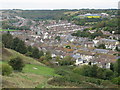
View across Dover from the Western Heights
Image: © Nick Smith
Taken: 14 Oct 2009
0.07 miles
2
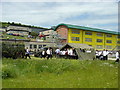
Astor College for the Arts
A cadet force display in progress at the Astor College for the Arts in Dover.
Image: © Adrian Beaumont
Taken: 15 Jun 2004
0.08 miles
3
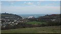
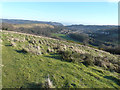
View of Dover Docks
As seen from Whinless Down.
Dover Castle is on the left and the Western Heights are on the right.
The bright green of Tower Hamlets School rugby ground is in the foreground.
Image: © David Anstiss
Taken: 27 Feb 2011
0.08 miles
4
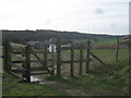
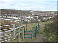
Kissing Gate entrance to Whinless Down
This gate is beside a footpath leading from Noah's Ark Road towards Long Wood.
It is one of many entrances to the open access land and nature reserve on the valley side.
Elms Vale Wood is seen in the background.
Image: © David Anstiss
Taken: 27 Feb 2011
0.12 miles
5
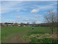
Recreational Ground beside Astor Vale
As seen from close to King's Road.
Image: © David Anstiss
Taken: 27 Feb 2011
0.12 miles
6
Kissing gate to St.Radigund's
This gate is beside a footpath from Long Wood to Noah's Ark Road. It heads into some open access land on the valley side.
Image: © David Anstiss
Taken: 27 Feb 2011
0.13 miles
7
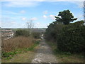
Track to Noah's Ark Road
This track (and footpath) leads from Whinless Down (open access land) towards the road in Dover.
Image: © David Anstiss
Taken: 27 Feb 2011
0.13 miles
8
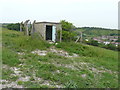
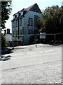
Derelict building
I don’t know what it was used for but the design of the fence indicates that access was barred to the public.
Image: © John Baker
Taken: 10 Jun 2016
0.15 miles
9
Looking east from Whinless Down
Dover Castle in Image is visible in the far distance, while to its right the white blobs are cross-channel ferries at the eastern docks.
Image: © John Baker
Taken: 4 Jan 2015
0.15 miles
10
Dover Grammar School for Boys, Astor Avenue
Viewed from Noah’s Ark Road, planning permission has been granted by Dover District Council under application number DOV 19/01120 for the “demolition of existing school buildings and proposed erection of a part three part four-storey teaching block with attached sports hall and associated hard and soft landscaping, a new multi-use games area (MUGA) together with parking and ancillary works”.
It is a difficult subject to photograph from this location as most of the school buildings are obscured by trees.
Image: © John Baker
Taken: 30 May 2020
0.16 miles