IMAGES TAKEN NEAR TO
Tower Hill, DOVER, CT17 0AG
Introduction
This page details the photographs taken nearby to Tower Hill, CT17 0AG by members of the Geograph project.
The Geograph project started in 2005 with the aim of publishing, organising and preserving representative images for every square kilometre of Great Britain, Ireland and the Isle of Man.

There are currently over 7.5m images from over14,400 individuals and you can help contribute to the project by visiting https://www.geograph.org.uk
Image Map
Images are licensed for reuse under creativecommons.org/licenses/by-sa/2.0
Notes
- Clicking on the map will re-center to the selected point.
- The higher the marker number, the further away the image location is from the centre of the postcode.
Image Listing (187 Images Found)
Images are licensed for reuse under creativecommons.org/licenses/by-sa/2.0
Image
Details
Distance
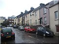
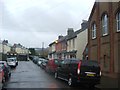
3
Bramley Hedge, Tower Street
A terrace of ten, 3-bedroom town houses still under construction.
Image: © John Baker
Taken: 5 Sep 2020
0.06 miles
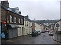
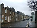
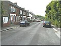
5
View to the north from Priory Hill
The road to the left of the yellow-bricked house is St Bartholomew's Close.
Image: © John Baker
Taken: 27 Sep 2013
0.08 miles
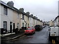
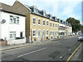
6
91-119 Priory Hill
Beyond the terrace is a more modern development known as The Abbots.
Image: © John Baker
Taken: 27 Sep 2013
0.08 miles
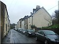
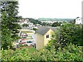
7
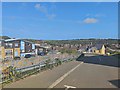
Tower Hamlets - Auden Way
View across the Dour Valley.
Dover history : https://doverhistorian.com/2016/06/25/dour-river-part-one-an-historical-overview/
Image: © James Emmans
Taken: 13 Sep 2020
0.08 miles