IMAGES TAKEN NEAR TO
Priory Hill, DOVER, CT17 0AE
Introduction
This page details the photographs taken nearby to Priory Hill, CT17 0AE by members of the Geograph project.
The Geograph project started in 2005 with the aim of publishing, organising and preserving representative images for every square kilometre of Great Britain, Ireland and the Isle of Man.

There are currently over 7.5m images from over14,400 individuals and you can help contribute to the project by visiting https://www.geograph.org.uk
Image Map
Images are licensed for reuse under creativecommons.org/licenses/by-sa/2.0
Notes
- Clicking on the map will re-center to the selected point.
- The higher the marker number, the further away the image location is from the centre of the postcode.
Image Listing (353 Images Found)
Images are licensed for reuse under creativecommons.org/licenses/by-sa/2.0
Image
Details
Distance
1
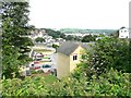
View to the north from Priory Hill
The road to the left of the yellow-bricked house is St Bartholomew's Close.
Image: © John Baker
Taken: 27 Sep 2013
0.03 miles
2
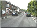
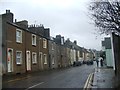
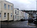
91-119 Priory Hill
Beyond the terrace is a more modern development known as The Abbots.
Image: © John Baker
Taken: 27 Sep 2013
0.05 miles
3
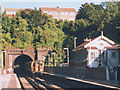
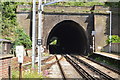
Priory Tunnel
The southern portal of Priory Tunnel, the first of two tunnels (the other being Charlton Tunnel) leading out of Dover Priory station. It was completed on 1 November 1861, according to http://en.wikipedia.org/wiki/Dover_Priory_railway_station
The train is no 421595 forming the 07.55 Charing Cross to Ramsgate service.
Image: © Stephen Craven
Taken: 14 Sep 1998
0.05 miles
8
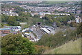
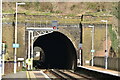
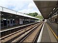
Dover Priory station
Dover Priory opened on 22nd July 1861 as the temporary terminus of the London, Chatham & Dover Railway from Canterbury East. It became a through station on 1st November 1861, with the completion of a tunnel through the Western Heights to gain access to the Western Docks area, where Dover Harbour station was built The station was known as Dover Town but was renamed in July 1863. This looks northwards towards Canterbury East and Ramsgate, the split being a little way north of the tunnel. The former signal box is on the right.
Image: © Marathon
Taken: 21 Aug 2022
0.06 miles
10
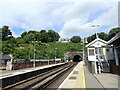
Dover Priory station
Dover Priory opened on 22nd July 1861 as the temporary terminus of the London, Chatham & Dover Railway from Canterbury East. It became a through station on 1st November 1861, with the completion of a tunnel through the Western Heights to gain access to the Western Docks area, where Dover Harbour station was built The station was known as Dover Town but was renamed in July 1863. This looks northwards towards Canterbury East and Ramsgate, the split being a little way north of the tunnel. See also https://www.geograph.org.uk/photo/7265366
Image: © Marathon
Taken: 21 Aug 2022
0.06 miles