IMAGES TAKEN NEAR TO
Scotland Common, CT16 3PY
Introduction
This page details the photographs taken nearby to Scotland Common, CT16 3PY by members of the Geograph project.
The Geograph project started in 2005 with the aim of publishing, organising and preserving representative images for every square kilometre of Great Britain, Ireland and the Isle of Man.

There are currently over 7.5m images from over14,400 individuals and you can help contribute to the project by visiting https://www.geograph.org.uk
Image Map
Images are licensed for reuse under creativecommons.org/licenses/by-sa/2.0
Notes
- Clicking on the map will re-center to the selected point.
- The higher the marker number, the further away the image location is from the centre of the postcode.
Image Listing (128 Images Found)
Images are licensed for reuse under creativecommons.org/licenses/by-sa/2.0
Image
Details
Distance
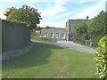
1

Bridleway to Summerhill Lodge
An access road/track and bridleway leads from Alkham Road towards Palmtree Hill Plantation and the lodge in the wood.
Image: © David Anstiss
Taken: 6 Mar 2011
0.06 miles
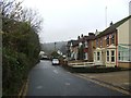
2
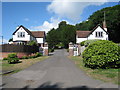
Entrance Lodges at Kearsney Court
Image: © Oast House Archive
Taken: 17 Jul 2010
0.10 miles
3
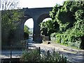
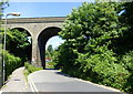
Lower Road and railway viaduct, Temple Ewell
Image: © Nick Smith
Taken: 6 Oct 2007
0.10 miles
5
Flint building near Kearsney Abbey
No.83 Lower Road. Opposite the ruins of Kearsney Abbey.
Image: © David Anstiss
Taken: 6 Mar 2011
0.11 miles
7
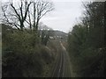
Railway to Kearsney
As seen from Image
This line leads from Canterbury towards Kearsney Station and onwards to Dover Priory.
In the background is Old Park Wood on Old park Hill, above Kearsney.
Image: © David Anstiss
Taken: 6 Mar 2011
0.11 miles
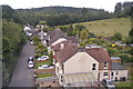
8
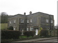
1 Kearsney Abbey Villas
In June 2013, this house was having an Image and this view shows how it looks in its finished state. The roadway in front of the house is called Scotland Common and it takes one up a very steep hill, to the left, to emerge on an area of land with the same name.
Image: © John Baker
Taken: 8 Jun 2014
0.11 miles
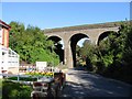
9
Kearsney Viaduct. Temple Ewell
On Lower Road.
Image: © pam fray
Taken: 24 Jun 2015
0.12 miles