IMAGES TAKEN NEAR TO
Cranleigh Drive, DOVER, CT16 3NW
Introduction
This page details the photographs taken nearby to Cranleigh Drive, CT16 3NW by members of the Geograph project.
The Geograph project started in 2005 with the aim of publishing, organising and preserving representative images for every square kilometre of Great Britain, Ireland and the Isle of Man.

There are currently over 7.5m images from over14,400 individuals and you can help contribute to the project by visiting https://www.geograph.org.uk
Image Map
Images are licensed for reuse under creativecommons.org/licenses/by-sa/2.0
Notes
- Clicking on the map will re-center to the selected point.
- The higher the marker number, the further away the image location is from the centre of the postcode.
Image Listing (15 Images Found)
Images are licensed for reuse under creativecommons.org/licenses/by-sa/2.0
Image
Details
Distance
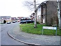
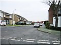
4
Housing around the recreation ground, Whitfield
Image: © Nick Smith
Taken: 22 Dec 2007
0.14 miles
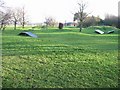
6
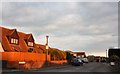
Newlands, Whitfield
The evening sun on the entrance to Newlands
Image: © MJ Reilly
Taken: 29 Mar 2009
0.17 miles
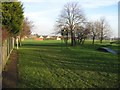
7
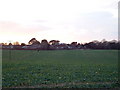
Whitfield (North)
Looking SE across fields to housing estates at the north of the town.
Image: © Chris Shaw
Taken: 31 Dec 2005
0.21 miles
8
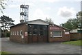
Whitfield fire station
Whitfield fire station, Sandwich Road, Whitfield, Kent
Image: © Kevin Hale
Taken: 28 Apr 2009
0.22 miles
9
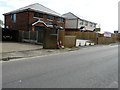
Two new houses, Archer?s Court Road
The Image has been completed but having consulted the plans, it would appear that another house is to be constructed.
Planning permission was granted by Dover District Council under application number DOV/15/00083 as the “erection of 3 dwellings and creation of vehicular access and parking”. The location was described as land at Elm Farm House (which is located to the left of these houses).
Image: © John Baker
Taken: 20 Aug 2017
0.22 miles
10
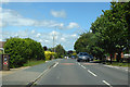
Sandwich Road, Whitfield
Towards Sandwich, this is the old route of the main Dover - Sandwich road.
Image: © Robin Webster
Taken: 15 Jun 2019
0.23 miles