IMAGES TAKEN NEAR TO
Mayfield Road, DOVER, CT16 3LH
Introduction
This page details the photographs taken nearby to Mayfield Road, CT16 3LH by members of the Geograph project.
The Geograph project started in 2005 with the aim of publishing, organising and preserving representative images for every square kilometre of Great Britain, Ireland and the Isle of Man.

There are currently over 7.5m images from over14,400 individuals and you can help contribute to the project by visiting https://www.geograph.org.uk
Image Map
Images are licensed for reuse under creativecommons.org/licenses/by-sa/2.0
Notes
- Clicking on the map will re-center to the selected point.
- The higher the marker number, the further away the image location is from the centre of the postcode.
Image Listing (18 Images Found)
Images are licensed for reuse under creativecommons.org/licenses/by-sa/2.0
Image
Details
Distance
1
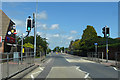
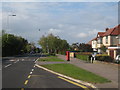
Pedestrian crossing by Whitfield post office
On Sandwich Road.
Image: © Robin Webster
Taken: 15 Jun 2019
0.04 miles
2
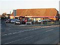
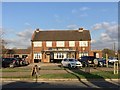
Village shop on junction of Bewsbury Cross Lane and Sandwich Road
Image: © Nick Smith
Taken: 15 Dec 2007
0.06 miles
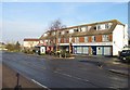
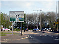
5
Sandwich Road
Long straight road running through Whitfield.
Image: © Oast House Archive
Taken: 7 May 2010
0.13 miles
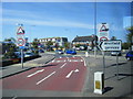
8
Approaching Whitfield Roundabout
The large roundabout joins the A2, A256, Sandwich Road, Honeywood Road.
Image: © Oast House Archive
Taken: 7 May 2010
0.16 miles
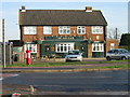
9
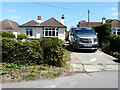
22, Bewsbury Cross Lane, Whitfield
Planning permission has been granted by Dover District Council under application number DOV/20/00409 for the “erection of a granny annexe and widening of existing vehicle access/driveway (existing garage to be demolished)”.
Image: © John Baker
Taken: 28 Jun 2020
0.16 miles
10
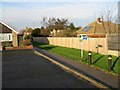
Footpath between recreation ground and the Sandwich Road
Left for the Sandwich Road, right for the recreation ground.
Image: © Nick Smith
Taken: 22 Dec 2007
0.17 miles