IMAGES TAKEN NEAR TO
Kittiwake Crescent, CT16 3HN
Introduction
This page details the photographs taken nearby to Kittiwake Crescent, CT16 3HN by members of the Geograph project.
The Geograph project started in 2005 with the aim of publishing, organising and preserving representative images for every square kilometre of Great Britain, Ireland and the Isle of Man.

There are currently over 7.5m images from over14,400 individuals and you can help contribute to the project by visiting https://www.geograph.org.uk
Image Map (Loading...)


Getting Data...Please wait
Leaflet Map data © OpenStreetMap
Images are licensed for reuse under creativecommons.org/licenses/by-sa/2.0
Notes
- Clicking on the map will re-center to the selected point.
- The higher the marker number, the further away the image location is from the centre of the postcode.
Image Listing (88 Images Found)
Images are licensed for reuse under creativecommons.org/licenses/by-sa/2.0
Image
Details
Distance
1
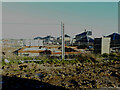
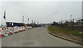
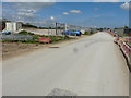
View of construction site, Richmond Road
The site has been named Richmond Park by Halsbury Homes https://www.halsburyhomes.com/richmond-park/
Image: © John Baker
Taken: 20 Nov 2022
0.01 miles
2
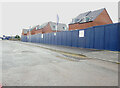
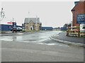
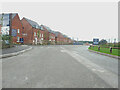
Richmond Road, Richmond Park
The site has been named Richmond Park by Halsbury Homes
https://halsburyhomes.com/richmond-park
Image: © John Baker
Taken: 9 Jul 2023
0.01 miles
3
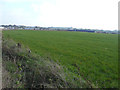
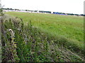
Distant view of a building site, Archer?s Court Road
Planning permission was granted by Dover District Council under application number DOV/10/01010 for an “outline planning application for the construction of up to 1,400 units, comprising a mix of 2-5 bed units, 66 bed care home (Class C2) and supported living units, with vehicular access off the A256; provision of new 420 place 2FE primary school including early years provision, energy centre and local centre comprising up to 250sqm of retail space (Class A1-A3) along with all associated access arrangements, car parking, infrastructure and landscaping, with all matters (except the means of access off the A256) reserved for future consideration (revised proposals)”. The description of the location was Phase 1, Whitfield Urban Extension, (land southeast of Archer’s Court Road).
The site has been named Richmond Park by Halsbury Homes http://www.halsburyhomes.com/richmond-park/
Image: © John Baker
Taken: 23 Oct 2016
0.02 miles
4
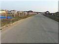
Richmond Road, Richmond Park
This view of Image was taken from the road in front of the car.
The site has been named Richmond Park by Halsbury Homes
https://www.halsburyhomes.com/richmond-park/
Image: © John Baker
Taken: 20 Mar 2022
0.02 miles
5
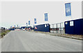
Richmond Road, Richmond Park
The recently-erected hoarding has replaced the fence, that was in this section of Image
The site has been named Richmond Park by Halsbury Homes
https://halsburyhomes.com/richmond-park
Image: © John Baker
Taken: 12 Feb 2023
0.02 miles
6
Unnamed road, Richmond Park
The site has been named Richmond Park by Halsbury Homes
https://halsburyhomes.com/richmond-park
Image: © John Baker
Taken: 9 Jul 2023
0.02 miles
7
Distant view of a building site, Archer?s Court Road
This is a similar view of Image but now there are now more building construction materials on the site and a roof of a newly constructed house is visible on the right of the frame
Planning permission was granted by Dover District Council under application number DOV/10/01010 for an “outline planning application for the construction of up to 1,400 units, comprising a mix of 2-5 bed units, 66 bed care home (Class C2) and supported living units, with vehicular access off the A256; provision of new 420 place 2FE primary school including early years provision, energy centre and local centre comprising up to 250sqm of retail space (Class A1-A3) along with all associated access arrangements, car parking, infrastructure and landscaping, with all matters (except the means of access off the A256) reserved for future consideration (revised proposals)”. The description of the location was Phase 1, Whitfield Urban Extension, (land southeast of Archer’s Court Road).
The site has been named Richmond Park by Halsbury Homes http://www.halsburyhomes.com/richmond-park/
Image: © John Baker
Taken: 20 Aug 2017
0.02 miles
8
Richmond Road, Richmond Park
The recently-erected hoarding has replaced the fence, that was in this section of Image
The site has been named Richmond Park by Halsbury Homes
https://halsburyhomes.com/richmond-park
Image: © John Baker
Taken: 12 Feb 2023
0.02 miles
9
Richmond Way, Richmond Park
Planning permission was granted by Dover District Council under application number DOV/10/01010 for an “outline planning application for the construction of up to 1,400 units, comprising a mix of 2-5 bed units, 66 bed care home (Class C2) and supported living units, with vehicular access off the A256; provision of new 420 place 2FE primary school including early years provision, energy centre and local centre comprising up to 250sqm of retail space (Class A1-A3) along with all associated access arrangements, car parking, infrastructure and landscaping, with all matters (except the means of access off the A256) reserved for future consideration (revised proposals)”. The description of the location was Phase 1, Whitfield Urban Extension, (land southeast of Archer’s Court Road).
The site has been named Richmond Park by Halsbury Homes http://www.halsburyhomes.com/richmond-park/
Image: © John Baker
Taken: 2 May 2019
0.02 miles
10
Richmond Road, Richmond Park
Showing the junction of an Image
The site has been named Richmond Park by Halsbury Homes
https://halsburyhomes.com/richmond-park
Image: © John Baker
Taken: 9 Jul 2023
0.02 miles