IMAGES TAKEN NEAR TO
Scotland Common, DOVER, CT16 3EA
Introduction
This page details the photographs taken nearby to Scotland Common, CT16 3EA by members of the Geograph project.
The Geograph project started in 2005 with the aim of publishing, organising and preserving representative images for every square kilometre of Great Britain, Ireland and the Isle of Man.

There are currently over 7.5m images from over14,400 individuals and you can help contribute to the project by visiting https://www.geograph.org.uk
Image Map (Loading...)


Getting Data...Please wait
Leaflet Map data © OpenStreetMap
Images are licensed for reuse under creativecommons.org/licenses/by-sa/2.0
Notes
- Clicking on the map will re-center to the selected point.
- The higher the marker number, the further away the image location is from the centre of the postcode.
Image Listing (17 Images Found)
Images are licensed for reuse under creativecommons.org/licenses/by-sa/2.0
Image
Details
Distance
1
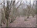
Bridleway in Scotland Common
This very faint woodland path leads from Ewell Minnis towards Temple Ewell. The path in this wood near Palmtree Hill Plantation can just be made out.
Image: © David Anstiss
Taken: 6 Mar 2011
0.06 miles
2
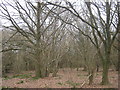
Scotland Common
This wood is beside a bridleway between Ewell Minnis and Kearsney, near Palmtree Hill Plantation.
Image: © David Anstiss
Taken: 6 Mar 2011
0.09 miles
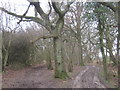
3
Track and bridleway junction in Palmtree Hill Plantation
A bridleway from Ewell Minnis leads past Summerhill Lodge in the wood and heads straight on towards Alkham Road. A track (and phone pylons) leads left towards another bridleway towards Temple Ewell.
Image: © David Anstiss
Taken: 6 Mar 2011
0.09 miles
4
Bridleway in Palm Tree Plantation
These two muddy trails lead through the wood (near Kearsney) towards Ewell Minis.
Image: © David Anstiss
Taken: 6 Mar 2011
0.14 miles
5
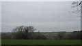
View from Palm Tree Plantation
Looking across the Lydden Valley.
Image: © David Anstiss
Taken: 6 Mar 2011
0.15 miles
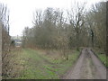
6
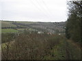
Bridleway to Temple Ewell
This track leads from Ewell Minnis towards Scotland Common (wood) and then down to the village (on the suburbs of Dover).
Image: © David Anstiss
Taken: 6 Mar 2011
0.19 miles
7

Bushy Ruff House
Large house built in 1860 by the then owner John Banks as an almost total rebuild of an earlier house. Following various owners over the years it was requisitioned for war use during the Second World War after which it fell into disuse. In 1973 it was put up for sale and part of the grounds, including the lake, were bought by Dover Council the following year as an extension of Russell Gardens. Other than a period as a nursing home in the 1980s/90s the house remained in disuse, despite various proposals for conversion either to a family home or apartments, and in 2010 suffered a serious fire.
Grade II listed - see www.historicengland.org.uk/listing/the-list/list-entry/1065713.
For fuller history see www.doverhistorian.com/2013/08/24/bushy-ruff/.
Image: © Ian Capper
Taken: 16 Jan 2017
0.19 miles
8
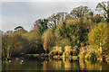
Russell Gardens
The lake in Russell Gardens, part of the 1974 Dover Council purchase.
Image: © Ian Capper
Taken: 16 Jan 2017
0.20 miles
9
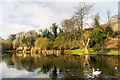
Russell Gardens
The lake in Russell Gardens, part of the 1974 Dover Council purchase.
Image: © Ian Capper
Taken: 16 Jan 2017
0.20 miles
10
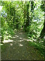
Bushy Ruff, Temple Ewell
A woodland path running along the north side of the park. Adjacent to Russell Gardens, this is a conservation and recreation area created on land purchased in 1974 and laid out as a country park. It is managed by the White Cliffs Countryside Project.
Image: © pam fray
Taken: 24 Jun 2015
0.21 miles