IMAGES TAKEN NEAR TO
Brookside, DOVER, CT16 3DP
Introduction
This page details the photographs taken nearby to Brookside, CT16 3DP by members of the Geograph project.
The Geograph project started in 2005 with the aim of publishing, organising and preserving representative images for every square kilometre of Great Britain, Ireland and the Isle of Man.

There are currently over 7.5m images from over14,400 individuals and you can help contribute to the project by visiting https://www.geograph.org.uk
Image Map
Images are licensed for reuse under creativecommons.org/licenses/by-sa/2.0
Notes
- Clicking on the map will re-center to the selected point.
- The higher the marker number, the further away the image location is from the centre of the postcode.
Image Listing (79 Images Found)
Images are licensed for reuse under creativecommons.org/licenses/by-sa/2.0
Image
Details
Distance
1
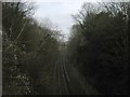
Railway to Shepherdswell
As seen from Image
This railway line leads from Dover Priory (via Kearsney) towards Shepherdswell and onwards to Canterbury.
Image: © David Anstiss
Taken: 6 Mar 2011
0.04 miles
2
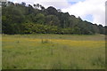
Temple Ewell from across the valley
The meadow is close to a bridleway that runs from Lower Road, Kearsney to Ewell Minnis. Temple Ewell also lies in Image
Image: © John Baker
Taken: 16 Jun 2013
0.05 miles
4
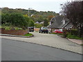
Close off Watersend
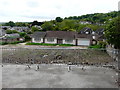
This close could be the access to ten semi-detached dwellings. Planning permission has been granted by Dover District Council under application number DOV/15/00123 for the “erection of ten semi-detached dwellings and creation of vehicular access and parking spaces (existing bungalow and garage to be demolished)(amended plans)”. It has been pointed out in comments, made by objectors, that the block-paving road surface would have to be replaced with one that is more suitable for greater use, should the houses be built.
Image: © John Baker
Taken: 23 Oct 2015
0.08 miles
5
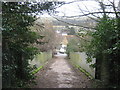
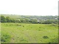
Bridleway bridge over the railway near Temple Ewell
A track leads down from Scotland Common (wood) towards Church Hill. It crosses over the railway between Canterbury and Dover.
Image: © David Anstiss
Taken: 6 Mar 2011
0.08 miles
6
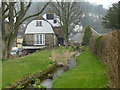
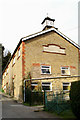
Mill stream and water mill
Viewed from the footbridge over the stream which runs between Mill Street and Brookside.
Image: © pam fray
Taken: 16 Mar 2011
0.10 miles
7
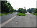
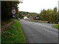
View along the B2060 road to Temple Ewell
Image: © Nick Smith
Taken: 24 May 2008
0.10 miles
8
Forge Bungalow from London Road
My last visit to Image was at the end of October 2016 and since then there has been no further development, not even to demolish Forge Bungalow. Therefore I took the opportunity to photograph it, while there was still time to do so. Planning permission was granted by Dover District Council under application number DOV/15/00123 for the “erection of ten semi-detached dwellings and creation of vehicular access and parking spaces (existing bungalow and garage to be demolished) (amended plans)”. The location was described as land at 191 and Forge Bungalow.
Image: © John Baker
Taken: 19 May 2017
0.10 miles
9
London Road
The building, opposite the parked cars, is a garage at 191, London Road. Planning permission has been granted by Dover District Council under application number DOV/15/00123 for the “erection of ten semi-detached dwellings and creation of vehicular access and parking spaces (existing bungalow and garage to be demolished)(amended plans)”. Access to the dwellings would be via Watersend (the road to the right) and the Image The location of the planning application reads land at 191 and Forge Bungalow, London Road, Temple Ewell.
Image: © John Baker
Taken: 23 Oct 2015
0.10 miles