IMAGES TAKEN NEAR TO
London Road, DOVER, CT16 3DJ
Introduction
This page details the photographs taken nearby to London Road, CT16 3DJ by members of the Geograph project.
The Geograph project started in 2005 with the aim of publishing, organising and preserving representative images for every square kilometre of Great Britain, Ireland and the Isle of Man.

There are currently over 7.5m images from over14,400 individuals and you can help contribute to the project by visiting https://www.geograph.org.uk
Image Map
Images are licensed for reuse under creativecommons.org/licenses/by-sa/2.0
Notes
- Clicking on the map will re-center to the selected point.
- The higher the marker number, the further away the image location is from the centre of the postcode.
Image Listing (25 Images Found)
Images are licensed for reuse under creativecommons.org/licenses/by-sa/2.0
Image
Details
Distance
1
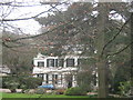
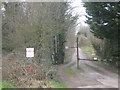
Woodville Hall
On a short access road from the London Road.
Image: © David Anstiss
Taken: 6 Mar 2011
0.01 miles
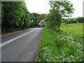
3
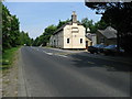
Bassingham Court on the B2060 London Road
Image: © Nick Smith
Taken: 24 May 2008
0.08 miles
5
Access lane to Stonehall Colliery
This track leads off the London Road and past Broadfield Farm to the disused colliery.
This disused colliery is mentioned in http://en.wikipedia.org/wiki/East_Kent_Light_Railway , being close to Guilford Colliery.
Image: © David Anstiss
Taken: 6 Mar 2011
0.09 miles
6
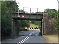
Railway Bridge on London Road
Carrying line between Dover and Canterbury.
Image: © Oast House Archive
Taken: 17 Jul 2010
0.09 miles
7
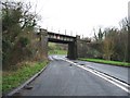
The London Dover line crosses the old A2 looking W
Image: © Nick Smith
Taken: 11 Feb 2007
0.10 miles
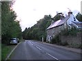
8
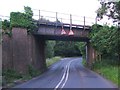
Railway bridge over London Road, Temple Ewell
Image: © Chris Whippet
Taken: 21 Jun 2015
0.12 miles
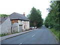
9
Sharp bend on the B2060 London Road
This was originally the A2, the main London to Dover road, the bend takes you under a railway bridge http://www.geograph.org.uk/photo/156259
Image: © Nick Smith
Taken: 18 May 2008
0.12 miles
10
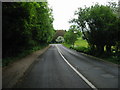
View along the B2060 London Road
The sharp bend on the road takes you under the railway line http://www.geograph.org.uk/photo/156259 on what was once the A2 London to Dover road, this bend was an accident blackspot.
Image: © Nick Smith
Taken: 18 May 2008
0.12 miles