IMAGES TAKEN NEAR TO
Whitfield Hill, DOVER, CT16 3BJ
Introduction
This page details the photographs taken nearby to Whitfield Hill, CT16 3BJ by members of the Geograph project.
The Geograph project started in 2005 with the aim of publishing, organising and preserving representative images for every square kilometre of Great Britain, Ireland and the Isle of Man.

There are currently over 7.5m images from over14,400 individuals and you can help contribute to the project by visiting https://www.geograph.org.uk
Image Map
Images are licensed for reuse under creativecommons.org/licenses/by-sa/2.0
Notes
- Clicking on the map will re-center to the selected point.
- The higher the marker number, the further away the image location is from the centre of the postcode.
Image Listing (8 Images Found)
Images are licensed for reuse under creativecommons.org/licenses/by-sa/2.0
Image
Details
Distance
1
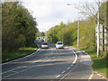
Whitfield Hill
The A256 towards Whitfield Roundabout.
Image: © Oast House Archive
Taken: 7 May 2010
0.07 miles
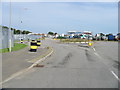
3
Roundabout on Menzies Road, Whitfield, Dover
Unusual bollards adorn the roadside.
Image: © Steve Fareham
Taken: 5 Mar 2009
0.16 miles
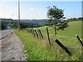
4
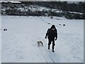
Winter toboggan site near Dover
Usually a grazing site for sheep but if it snows it's soon taken over by toboggans and sledges.
Image: © Nick Smith
Taken: 3 Mar 2005
0.16 miles
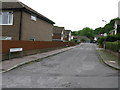
6
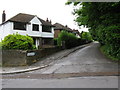
View along Whitfield Hill
The main road, the A256 which runs parallel is also called Whitfield Hill.
Image: © Nick Smith
Taken: 28 May 2009
0.21 miles
7
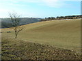
Grazing near Whitfield
Looking SW down towards River.
Image: © Chris Shaw
Taken: 31 Dec 2005
0.22 miles