IMAGES TAKEN NEAR TO
Millais Road, DOVER, CT16 2LW
Introduction
This page details the photographs taken nearby to Millais Road, CT16 2LW by members of the Geograph project.
The Geograph project started in 2005 with the aim of publishing, organising and preserving representative images for every square kilometre of Great Britain, Ireland and the Isle of Man.

There are currently over 7.5m images from over14,400 individuals and you can help contribute to the project by visiting https://www.geograph.org.uk
Image Map (Loading...)


Getting Data...Please wait
Leaflet Map data © OpenStreetMap
Images are licensed for reuse under creativecommons.org/licenses/by-sa/2.0
Notes
- Clicking on the map will re-center to the selected point.
- The higher the marker number, the further away the image location is from the centre of the postcode.
Image Listing (207 Images Found)
Images are licensed for reuse under creativecommons.org/licenses/by-sa/2.0
Image
Details
Distance
1
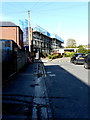
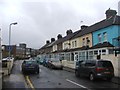
Leighton Court, Leighton Road
Leighton Court is a sheltered housing scheme which offers purpose-built properties for rent for people over the age of 55 http://www.housingcare.org/housing-care/facility-info-10492-leighton-court-dover-england.aspx
The building’s exterior appears to be undergoing maintenance.
Image: © John Baker
Taken: 9 Nov 2019
0.04 miles
2
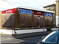
Former Blaze showroom, Beaconsfield Road
Specializing in fireplaces, heating centres, bathroom suites, showers and kitchens.
Image: © John Baker
Taken: 21 Dec 2012
0.04 miles
3
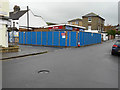
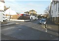
Building site, Beaconsfield Road
Planning permission has been granted by Dover District Council under application number DOV/14/00301 for the “erection of four town houses with 3 integral garages and creation of one car parking space (existing building to be demolished)”. This is Image before the hoarding was erected.
Image: © John Baker
Taken: 6 Nov 2015
0.04 miles
4
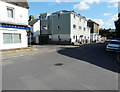
9-11, Beaconsfield Road
Until the houses had been completed, this location was a Image
Image: © John Baker
Taken: 11 Aug 2017
0.04 miles
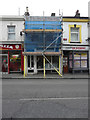
5
17, Beaconsfield Road
Scaffolding has been erected to the top of the chimney. To the left, Jermains Restaurant is situated on the corner of Leighton Road.
Image: © John Baker
Taken: 12 Sep 2014
0.04 miles
6
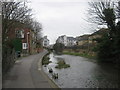
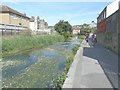
The River Dour towards Beaconsfield Avenue
This riverside path leads from Cherry Tree Avenue leading beside the River Dour towards Beaconsfield Avenue. On the left is Charlton Avenue.
Image: © David Anstiss
Taken: 6 Mar 2011
0.04 miles
8
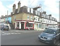
Beaconsfield Road, Dover
Taken from its junction with Granville Street and showing Image on the corner of Millais Road.
Image: © John Baker
Taken: 21 Dec 2012
0.05 miles
9
Flowering water plants in the River Dour
Seen from Barton Path.
Image: © John Baker
Taken: 6 Jun 2014
0.05 miles
10
Refurbishment of 65, London Road
Planning permission has been granted by Dover District Council under application number DOV/16/00299 for the “erection of a first floor single storey front extension”. This used to be a butchers called R Veness.
Image: © John Baker
Taken: 10 Feb 2017
0.05 miles