IMAGES TAKEN NEAR TO
Dunedin Drive, DOVER, CT16 2JU
Introduction
This page details the photographs taken nearby to Dunedin Drive, CT16 2JU by members of the Geograph project.
The Geograph project started in 2005 with the aim of publishing, organising and preserving representative images for every square kilometre of Great Britain, Ireland and the Isle of Man.

There are currently over 7.5m images from over14,400 individuals and you can help contribute to the project by visiting https://www.geograph.org.uk
Image Map
Images are licensed for reuse under creativecommons.org/licenses/by-sa/2.0
Notes
- Clicking on the map will re-center to the selected point.
- The higher the marker number, the further away the image location is from the centre of the postcode.
Image Listing (13 Images Found)
Images are licensed for reuse under creativecommons.org/licenses/by-sa/2.0
Image
Details
Distance
2
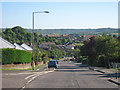
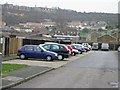
Looking S down Melbourne Avenue, Buckland Valley
Image: © Nick Smith
Taken: 4 Mar 2007
0.17 miles
3
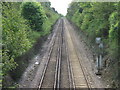
Railway to Deal
This railway in a cutting heads from Dover under Green Lane, before heading out to Martin Mill, Walmer and Deal Stations.
Image: © David Anstiss
Taken: 2 May 2009
0.17 miles
5
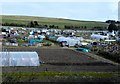
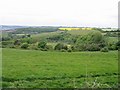
Looking SW towards Long Hill and Buckland
Image: © Nick Smith
Taken: 18 Oct 2009
0.20 miles
6
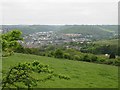
View across to Buckland from the Burgoyne Heights
Image: © Nick Smith
Taken: 5 May 2007
0.21 miles
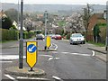
8
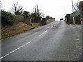
Looking NE up Green Lane to bridge over railway
Image: © Nick Smith
Taken: 4 Mar 2007
0.22 miles
9
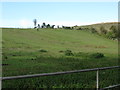
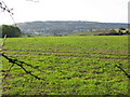
Paddock to W of North Downs Way near Buckland
Image: © Nick Smith
Taken: 18 Oct 2009
0.22 miles