IMAGES TAKEN NEAR TO
Durban Crescent, DOVER, CT16 2JJ
Introduction
This page details the photographs taken nearby to Durban Crescent, CT16 2JJ by members of the Geograph project.
The Geograph project started in 2005 with the aim of publishing, organising and preserving representative images for every square kilometre of Great Britain, Ireland and the Isle of Man.

There are currently over 7.5m images from over14,400 individuals and you can help contribute to the project by visiting https://www.geograph.org.uk
Image Map
Images are licensed for reuse under creativecommons.org/licenses/by-sa/2.0
Notes
- Clicking on the map will re-center to the selected point.
- The higher the marker number, the further away the image location is from the centre of the postcode.
Image Listing (11 Images Found)
Images are licensed for reuse under creativecommons.org/licenses/by-sa/2.0
Image
Details
Distance
4
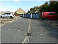
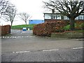
Garage block, Kimberley Close
Planning permission has been granted by Dover District Council under application number DOV/20/00187 for the “erection of 2 buildings incorporating 16 flats, associated car parking and landscaping (existing garages to be demolished)”.
Image: © John Baker
Taken: 12 Sep 2020
0.17 miles
6
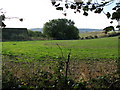
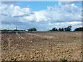
Farmland and Whiting Farm
Taken from a footpath that connects Whitfield to the North Downs Way.
Image: © Nick Smith
Taken: 18 Oct 2009
0.22 miles
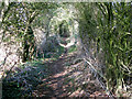
7

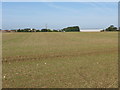
Looking SW from footpath to Whitfield
The footpath links with the North Downs Way
Image: © Nick Smith
Taken: 18 Oct 2009
0.23 miles
8
View N along the North Downs Way
Part of the North Downs Way the White Cliffs Country Trail and it is also a Roman road.
Image: © Nick Smith
Taken: 18 Oct 2009
0.24 miles
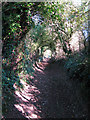
9
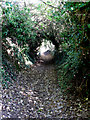
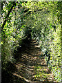
Looking N along the North Downs Way
The path has obviously been used a lot in the past as it is well below the level of the banks either side and in some places such as here is enclosed by vegetation to make a tunnel.
Image: © Nick Smith
Taken: 18 Oct 2009
0.24 miles