IMAGES TAKEN NEAR TO
Maison Dieu Gardens, DOVER, CT16 1TG
Introduction
This page details the photographs taken nearby to Maison Dieu Gardens, CT16 1TG by members of the Geograph project.
The Geograph project started in 2005 with the aim of publishing, organising and preserving representative images for every square kilometre of Great Britain, Ireland and the Isle of Man.

There are currently over 7.5m images from over14,400 individuals and you can help contribute to the project by visiting https://www.geograph.org.uk
Image Map
Images are licensed for reuse under creativecommons.org/licenses/by-sa/2.0
Notes
- Clicking on the map will re-center to the selected point.
- The higher the marker number, the further away the image location is from the centre of the postcode.
Image Listing (705 Images Found)
Images are licensed for reuse under creativecommons.org/licenses/by-sa/2.0
Image
Details
Distance
1
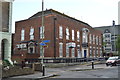
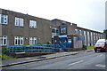
Dover Bowling Club Pavilion, Maison Dieu Gardens
Planning permission has been granted by Dover District Council under application number DOV/20/01399 for the “installation of replacement double doors”. The doors mentioned in the planning permission are those, at present, painted blue.
This was Image after the installation of the replacement doors.
Image: © John Baker
Taken: 27 Mar 2021
0.01 miles
2
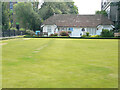
Dover Bowling Club Pavilion, Maison Dieu Gardens
This view shows Image before the installation of replacement double doors. The former doors were painted blue; now they are white.
Image: © John Baker
Taken: 24 Jul 2021
0.01 miles
3

Port of Dover - 2004
Port of Dover, Breakwater, seen from Dover to Calais Hoverspeed Catamaran Ferry 'SeaCat Diamant'.
Image: © Helmut Zozmann
Taken: Unknown
0.02 miles
6
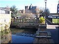
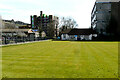
Footbridge over River Dour
River goes through town centre, but is only visible in a few places. Here in between large carpark on Maison Dieu Road and Biggin Street, going past Library and Tourist Information Centre. Green lawn and white building on right are part of a Bowls Club.
Image: © David Anstiss
Taken: 21 Feb 2009
0.04 miles
7
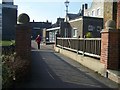
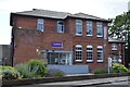
Footbridge over River Dour
Leads into Dover pedestrianized Biggin Street from carpark on Maison Dieu Road.
Goes past the back of the Library/Information Centre.
Image: © David Anstiss
Taken: 21 Feb 2009
0.04 miles
8
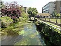
Dover, River Dour
Dover, River Dour seen from footbridge at Bowling Green.
Image: © Helmut Zozmann
Taken: 3 Aug 2011
0.04 miles
9
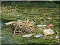
Rubbish nest on River Dour
A Moorhen nest amongst the disgusting River which is strewn with rubbish.
Image: © Oast House Archive
Taken: 1 Jul 2017
0.04 miles