IMAGES TAKEN NEAR TO
Pencester Gardens, DOVER, CT16 1NS
Introduction
This page details the photographs taken nearby to Pencester Gardens, CT16 1NS by members of the Geograph project.
The Geograph project started in 2005 with the aim of publishing, organising and preserving representative images for every square kilometre of Great Britain, Ireland and the Isle of Man.

There are currently over 7.5m images from over14,400 individuals and you can help contribute to the project by visiting https://www.geograph.org.uk
Image Map (Loading...)


Getting Data...Please wait
Leaflet Map data © OpenStreetMap
Images are licensed for reuse under creativecommons.org/licenses/by-sa/2.0
Notes
- Clicking on the map will re-center to the selected point.
- The higher the marker number, the further away the image location is from the centre of the postcode.
Image Listing (1285 Images Found)
Images are licensed for reuse under creativecommons.org/licenses/by-sa/2.0
Image
Details
Distance
1
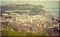
View over Dover from the Western Heights in 1968
The eye is drawn to the castle with the terrace of houses below in Victoria Park, which date from 1864 and were built to accommodate the officers of the Dover garrison. Below the terrace, Castle Street can be seen. On the seaward side of the view is the modern block of flats along Marine Parade, which on their landward side are separated from the bus station, in its former location, by Townwall Street. The Eastern Docks can also be seen in the distance.
Image: © John Baker
Taken: Unknown
0.02 miles
2
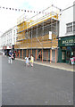
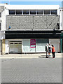
Scaffolding on former shops, Biggin Street
The shops were Vision Options, Lipgloss and Superdrug (respectively). They may be undergoing external and internal alterations.
Image: © John Baker
Taken: 31 Aug 2019
0.03 miles
3
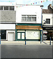
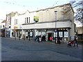
35 Biggin Street
Image: © John Baker
Taken: 18 Sep 2021
0.03 miles
4
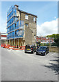
39-41, Biggin Street
Planning permission has been granted by Dover District Council under application numbers DOV/18/00705 for the “change of use to Class A3 (food and drink for consumption on the premises)” and DOV/18/00707 for the “change of use to Class D2 (entertainment and leisure)”. The nearest part of the building is being refurbished.
Image: © John Baker
Taken: 5 Jan 2019
0.03 miles
5
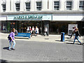
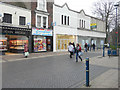
Marks and Spencer, 28, Biggin Street
This is the main entrance to the store, where notices have been posted in the windows that it is due to close on 15 May 2018 and to reopen as Image the following day.
Image: © John Baker
Taken: 11 May 2018
0.03 miles
6
Outlet Store, Cannon Street
This shop used to be a Dorothy Perkins.
Image: © John Baker
Taken: 10 Nov 2017
0.03 miles
7
39-41, Biggin Street
Planning permission has been granted by Dover District Council under application numbers DOV/18/00705 for the “change of use to Class A3 (food and drink for consumption on the premises)” and DOV/18/00707 for the “change of use to Class D2 (entertainment and leisure)”. It appears that this part of the building is being refurbished.
Image: © John Baker
Taken: 5 Jan 2019
0.03 miles
8
Re-rendering southern side of 21, Pencester Road
The carpark is for the use of Marks and Spencer customers.
Image: © John Baker
Taken: 15 Jul 2016
0.03 miles
9
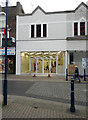
33-34, Biggin Street
This used to be a Superdrug outlet. This image of Image shows where it is located now.
Image: © John Baker
Taken: 11 May 2018
0.03 miles
10
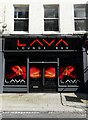
Lava, Biggin Street
This used to be a shop called Vision Express, which was part of Image Now Lava, a lounge bar, is occupying the site.
Image: © John Baker
Taken: 29 Mar 2019
0.03 miles