IMAGES TAKEN NEAR TO
Connaught Road, DOVER, CT16 1HB
Introduction
This page details the photographs taken nearby to Connaught Road, CT16 1HB by members of the Geograph project.
The Geograph project started in 2005 with the aim of publishing, organising and preserving representative images for every square kilometre of Great Britain, Ireland and the Isle of Man.

There are currently over 7.5m images from over14,400 individuals and you can help contribute to the project by visiting https://www.geograph.org.uk
Image Map
Images are licensed for reuse under creativecommons.org/licenses/by-sa/2.0
Notes
- Clicking on the map will re-center to the selected point.
- The higher the marker number, the further away the image location is from the centre of the postcode.
Image Listing (137 Images Found)
Images are licensed for reuse under creativecommons.org/licenses/by-sa/2.0
Image
Details
Distance
1
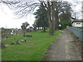
North Downs Way beside Connaught Park
The long distance path leads up from Connaught Road, beside the park (on the right) towards Old Charlton Road. On the left is St. Peter's Cemetery.
Image: © David Anstiss
Taken: 6 Mar 2011
0.03 miles
3
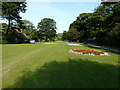
Summer bedding, Connaught Park
There is a small aviary beside the path, to the right of the ‘centre’ flowerbed, which contains a few cockatiels. I overheard a conversation, while walking past a couple, that once all the birds have lived out their natural lives, the aviary will not be replenished. It certainly seemed, to me, that there were fewer birds in the aviary than when I last visited it, at the end of January 2015. Besides the aviary, the park contains public conveniences, which are open on Sundays and an all weather shelter, as well as benches and a small lake that children may use for sailing toy boats on.
Image: © John Baker
Taken: 7 Aug 2015
0.06 miles
4
The North Downs Way alongside Connaught Park, Dover
St Mary's Cemetery on the left
Image: © Tim Heaton
Taken: 9 Aug 2019
0.09 miles
5
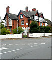
Bleriots, 47, Park Avenue
Planning permission has been granted by Dover District Council under application number DOV/21/01137 for a “change of use of guest house to residential with internal layout alterations”.
Image: © John Baker
Taken: 13 Nov 2021
0.09 miles
6
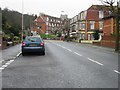
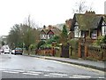
Looking SE along Barton Road
Dover Castle visible in background
Image: © Nick Smith
Taken: 4 Mar 2007
0.10 miles
8
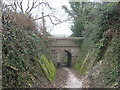
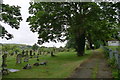
North Downs Way in St.Peter's Cemetery
The long distance path leads from Connaught Road to Old Charlton Road. The bridge carries a track between various parts of the cemetery.
Image: © David Anstiss
Taken: 6 Mar 2011
0.11 miles
9
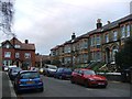
St Alphege House, Frith Road
It is also situated on the corner of St Alphege Road, where a notice had been attached to a tree to warn motorists not to park their vehicles in front of two trees, marked with crosses to the right of the notice, as these were to be cut down on 22 July 2014.
Image: © John Baker
Taken: 18 Jul 2014
0.11 miles
10
A new look for Alphege House, Frith Road
A number of trees were cut down on 22 July along the house’s northern boundary to reveal this new aspect. This is how Image appeared a week earlier.
Image: © John Baker
Taken: 25 Jul 2014
0.11 miles