IMAGES TAKEN NEAR TO
Westcourt Lane, DOVER, CT15 7PS
Introduction
This page details the photographs taken nearby to Westcourt Lane, CT15 7PS by members of the Geograph project.
The Geograph project started in 2005 with the aim of publishing, organising and preserving representative images for every square kilometre of Great Britain, Ireland and the Isle of Man.

There are currently over 7.5m images from over14,400 individuals and you can help contribute to the project by visiting https://www.geograph.org.uk
Image Map
Images are licensed for reuse under creativecommons.org/licenses/by-sa/2.0
Notes
- Clicking on the map will re-center to the selected point.
- The higher the marker number, the further away the image location is from the centre of the postcode.
Image Listing (231 Images Found)
Images are licensed for reuse under creativecommons.org/licenses/by-sa/2.0
Image
Details
Distance
2
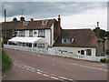
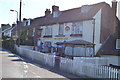
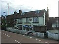
Bricklayers Arms, Shepherdswell
A Shepherd Neame pub on Coxhill Road. Seen from Church Hill across crossroad junction with Coxhill Road and Westcourt Road. The pub straddles the grid square with Image
Image: © Oast House Archive
Taken: 17 Jul 2010
0.03 miles
3
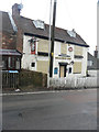
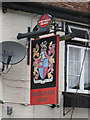
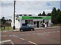
Bricklayers Arms, Coxhill Road
According to http://www.dover-kent.com/Bricklayers-Arms-Shepherdswell.html this public house closed on 21 September 2015.
Image: © John Baker
Taken: 31 Jan 2016
0.03 miles