IMAGES TAKEN NEAR TO
Hill Avenue, DOVER, CT15 7PA
Introduction
This page details the photographs taken nearby to Hill Avenue, CT15 7PA by members of the Geograph project.
The Geograph project started in 2005 with the aim of publishing, organising and preserving representative images for every square kilometre of Great Britain, Ireland and the Isle of Man.

There are currently over 7.5m images from over14,400 individuals and you can help contribute to the project by visiting https://www.geograph.org.uk
Image Map
Images are licensed for reuse under creativecommons.org/licenses/by-sa/2.0
Notes
- Clicking on the map will re-center to the selected point.
- The higher the marker number, the further away the image location is from the centre of the postcode.
Image Listing (286 Images Found)
Images are licensed for reuse under creativecommons.org/licenses/by-sa/2.0
Image
Details
Distance
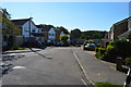
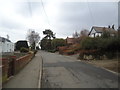
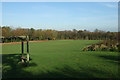
1
Hill Avenue, Shepherdswell
An unmade road serving a few houses with the Recreation Ground on the right.
Image: © steve
Taken: 16 Nov 2007
0.06 miles
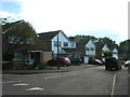
2
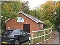
Shepherdswell Scout and Guide Club Hall
This building at the end of Approach Road, near Shepherdswell Recreational Ground. It is also used by Shepherdswell Football club (on Sundays) as a changing room.
Image: © David Anstiss
Taken: 31 Oct 2010
0.07 miles
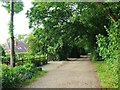
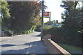
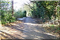
8
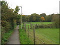
Footpath towards Shepherdswell Recreation Ground
This path leads from Moon Hill towards Approach Road.
Image: © David Anstiss
Taken: 31 Oct 2010
0.10 miles