IMAGES TAKEN NEAR TO
Eythorne Road, DOVER, CT15 7NU
Introduction
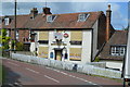
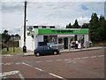
This page details the photographs taken nearby to Eythorne Road, CT15 7NU by members of the Geograph project.
The Geograph project started in 2005 with the aim of publishing, organising and preserving representative images for every square kilometre of Great Britain, Ireland and the Isle of Man.

There are currently over 7.5m images from over14,400 individuals and you can help contribute to the project by visiting https://www.geograph.org.uk
Image Map
Images are licensed for reuse under creativecommons.org/licenses/by-sa/2.0
Notes
- Clicking on the map will re-center to the selected point.
- The higher the marker number, the further away the image location is from the centre of the postcode.
Image Listing (241 Images Found)
Images are licensed for reuse under creativecommons.org/licenses/by-sa/2.0
Image
Details
Distance
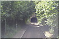
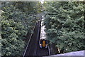
8
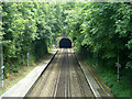
Platforms at Shepherdswell looking towards Dover
Just beyond the platform ends is the north end of Lydden Tunnel.
Image: © Robin Webster
Taken: 12 Jun 2014
0.02 miles