IMAGES TAKEN NEAR TO
Coxhill, DOVER, CT15 7NG
Introduction
This page details the photographs taken nearby to Coxhill, CT15 7NG by members of the Geograph project.
The Geograph project started in 2005 with the aim of publishing, organising and preserving representative images for every square kilometre of Great Britain, Ireland and the Isle of Man.

There are currently over 7.5m images from over14,400 individuals and you can help contribute to the project by visiting https://www.geograph.org.uk
Image Map
Images are licensed for reuse under creativecommons.org/licenses/by-sa/2.0
Notes
- Clicking on the map will re-center to the selected point.
- The higher the marker number, the further away the image location is from the centre of the postcode.
Image Listing (8 Images Found)
Images are licensed for reuse under creativecommons.org/licenses/by-sa/2.0
Image
Details
Distance
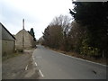
1
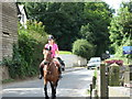
Coxhill at Diamond Farm
Showing narrow road and cars.
Image: © steve
Taken: 31 Jul 2007
0.02 miles
3
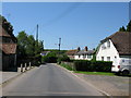
Oast Cottages, Coxhill, Shepherdswell
Image: © Oast House Archive
Taken: 17 Jul 2010
0.14 miles
5
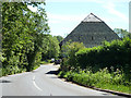
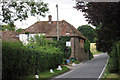
Coxhill Road by Coxhill Farm
The barn is one of the older buildings here.
Image: © Robin Webster
Taken: 4 Jun 2015
0.21 miles
6
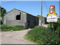
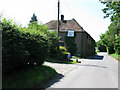
Farm buildings on Coxhill Road, Sheperdswell
Image: © Nick Smith
Taken: 31 May 2009
0.22 miles
8
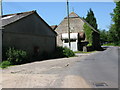
Coxhill Farm buildings near Halfway Street
Image: © Nick Smith
Taken: 31 May 2009
0.22 miles